Recommended Voluntary Forest Management Practices for New Hampshire
4.3 FOREST MANAGEMENT IN RIPARIAN AREAS
BACKGROUND
Riparian areas should be managed to protect water quality, streamflows, fish and wildlife habitat, and scenic values.
A riparian area is land adjacent to and directly influenced by streams, rivers, ponds, lakes, and associated nonforested wetlands. It forms a transition from aquatic to terrestrial ecosystems. Soils and growing conditions are often moister, more nutrient-rich, and more productive than those in surrounding uplands, resulting in considerable species diversity and productivity. Because of their proximity to surface waters, riparian areas are vital for maintaining water quality and aquatic resources.
Riparian areas have a long history of use and alteration by humans, including urbanization, road-building, agriculture, dam-building, and timber harvesting. The combined pressures of these activities, along with the documented ecological significance of these areas, underscore the importance of properly managing the riparian forest.
The Functions and Values of Riparian Areas
Riparian areas provide many ecosystem services and benefits such as:
- Flood control and streamflow regulation, especially where the riparian area includes a river's floodplain.
- Water-quality protection by filtering and retaining sediment, nutrients, and other pollutants from upslope areas, as well as through bank stabilization.
- Aquatic habitat protection including:
- Regulating temperatures by shading streams, particularly important for lower-order streams that support coldwater fish (e.g., brook trout). Increases in water temperature can have negative effects on stream chemistry, aquatic insects, stream flora, and fish.
- Large, woody material (e.g., fallen trees and large branches) that creates pools, riffles, debris-jams, and related aquatic habitat including spawning habitat for brook trout.
- Leaves, twigs, fruit and insects contributing energy (food) to drive aquatic food webs. Headwater streams and small rivers derive most of their energy this way.
- Fish habitat during high flow periods.
- Rare natural communities (e.g., calcareous riverside seeps, swamp white oak floodplain forest) and many rare plants. More than one-third of all New Hampshire's vascular plants occur in riparian natural communities, including 93 rare species.
- Habitat for feeding, cover, and travel for many amphibians, birds, furbearers, and reptiles. Deer wintering areas are often associated with riparian softwood forest. Large trees in these areas are the primary nesting sites for bald eagles, osprey, and colonial waterbirds.
- Recreational and scenic opportunities, such as hiking, fishing, hunting, boating, bird-watching, and wildlife viewing.
Identifying Riparian Areas and Designing Riparian Management Zones
Riparian areas are defined by their location adjacent to lakes, ponds, streams and rivers, by their characteristic vegetation, and by the function they serve. Vegetation can vary from a narrow band of shrubs to floodplain forests hundreds of yards wide. The size depends on what function is being considered and may include upland forest as well as truly riparian communities.
Riparian management zones (RMZs) are linear zones along the shores of lakes, ponds, rivers, streams, and associated wetlands, within which special forest management practices are used.
Just how wide should the RMZ be? Unique combinations of ecological functions, physical characteristics, and landscape context make it difficult to arrive at a one-size-fits-all width. An important first step is to identify what you wish to protect—the width needed to provide shade to a stream, for example, may be one tree height or less, whereas riparian wildlife habitat may extend several hundred feet into upland forests adjacent to a river or lake. Foresters and landowners are in the best position to consider and apply localized factors.
Variable, tailor-made RMZs reflect localized site conditions, but are generally more complicated to consistently define, apply, and monitor. Fixed-width RMZs have the practical benefit of being clear, consistent, relatively simple to apply and monitor, and provide reasonable confidence that RMZ values and goals will be attained. We suggest a tiered approach that provides the practical benefits of a fixed-width, but includes key modifiers offering some added benefits of a variable-width approach. For additional information about establishing RMZs, see chapter 2 in Riparian Management in Forests of the Continental Eastern United States.
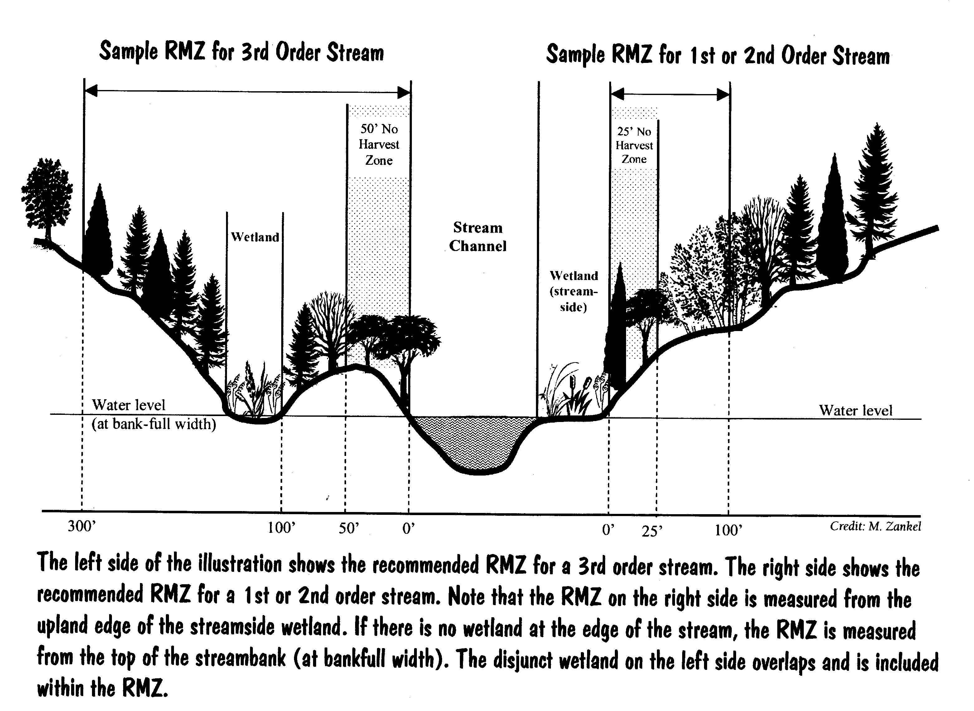
We recommend the following widths as general guidelines. The RMZ extends upland from the top of the streambank or from the upland edge of any stream-, pond-, or lake-side wetland (see illustration).
Table 1. Guidelines for Riparian Management Zones
Legally Required1 |
Recommended |
|||
Riparian Management |
No |
Riparian Management |
No Harvest |
|
Intermittent streams |
none1 |
none |
75 |
None |
1st and 2nd order streams |
501 |
none |
100 |
25 |
3rd order streams5 |
501 |
none |
3004 |
503 |
4th order and larger streams5 |
1501 |
none |
3004 |
25 |
Pond <10 acres |
501 |
none |
100 |
None |
Lake or Great Pond (>10 acres) |
1501 |
none |
300 |
25 |
1 Width required under RSA 227-J:9 (basal area law). Within a 12-month period, no more than 50 percent of the basal area may be cut in these areas. Includes ponds less than 10 acres associated with a stream or brook that flows throughout the year.
2 Portion directly adjacent to the water body in which no cutting is recommended. It may be desirable to expand if there are steep slopes (>25%), unstable soils, sensitive wetlands, or exemplary natural communities. Increasing the width of the no-harvest zone will provide greater protection of nontimber values, but will also encumber a larger amount of timber. There may be valid ecological and silvicultural reasons to harvest in the no-harvest zone.
3 A 50-foot, no-harvest zone is recommended for 3rd order streams because of the importance of large woody material on streams of this size.
4 RMZ width on 3rd & 4th order and larger streams and rivers may expand to encompass known wildlife travel corridors, drinking water supply considerations, and the full extent of the 100-year floodplain.
5 For a list of fourth-order and higher streams see N.H. Dept. of Environmental Services Consolidated List of Waterbodies Subject to RSA 483-B.

OBJECTIVE
Maintain the important ecological functions and values of forested riparian areas.
CONSIDERATIONS
- Wetland permits (RSA 482-A) or other legal requirements (RSA 227-J) may apply to forestry operations in riparian areas (4.2 Wetlands). Timber harvesting is exempt from RSA 483-B, the Comprehensive Shoreland Protection Act, so long as it isn't associated with shoreland development or land conversion and is conducted in compliance with RSA 227-J:9.
- Landowner objectives, water-body size, landscape context, vegetative composition, slope, and other factors helps determine the appropriate width and management of RMZs.
- There are benefits to managing riparian areas with a long-term perspective (>100 years). Some potential effects of harvesting in riparian areas may be short-lived; others (e.g., reduced input of large woody material) are much longer lasting. Trees retained today become the source of key terrestrial and instream habitat structure many decades into the future.
- No harvest zones within an RMZ provide optimal water quality benefits, protect sensitive riparian natural communities and wildlife movement corridors, promote quantities of large woody material, and avoid soil disturbance.
- Active forest management can be compatible with maintaining riparian functions and values. Trees regenerated today will provide the future source of cover, cavity trees, woody material, and snags. Some silvicultural and wildlife habitat objectives can conflict with no-harvest or limited harvest RMZs. For example, maintaining beavers at an active flowage within a particular stream reach may require active tree harvesting within these zones (6.8 Beaver-Created Openings). Soil scarification improves the likelihood of regenerating white pine, red oak, or red spruce, and may conflict with the recommendation to minimize ground disturbance.
- Riparian forests may be highly productive. Limiting harvesting in RMZs will entail some financial loss to riparian landowners.
- The integrity of aquatic and riparian ecosystems may be affected by activities of others throughout the watershed.
RECOMMENDED PRACTICES
- Survey the property (ideally in early spring) and identify important hydrologic features such as rivers, streams, lakes and ponds.
- Establish RMZs along streams, rivers, ponds, and lakes. Recommended minimum zone widths and key considerations are described above and reflected in Table 1.
- Include maintaining or restoring riparian functions and values as a silvicultural objective in RMZs.
- Retain trees with cavities, standing dead trees, downed logs, and large supracanopy trees (especially white pine).
- Leave windfirm trees that are well-distributed. Leave other vegetation, including existing groundcover.
- Choose a regeneration system most likely to maintain riparian functions and values and rapidly regenerate the site with the desired trees. Choosing a method is complicated by wet soils and the desire to maintain forest structure that contributes to wildlife habitat and other ecological values.
- Use uneven-aged techniques such as single tree or small group selection, maintaining 60 to 70 percent crown closure or full stocking as recommended in silvicultural guides. (To convert crown closure percentages to basal area, see Leak and Tubbs 1983).
- Use even-aged techniques such as shelterwood or patch cuts to achieve regeneration goals when rapid regeneration is likely (2.3 Regeneration Methods).
- Locate new truck roads and log landings outside RMZs, except where doing so would result in greater overall adverse environmental impacts.
- Design roads and skid trails within RMZs to minimize the long-term impacts on water quality and wildlife habitat. Apply BMPs according to guidelines in Best Management Practices for Erosion Control on Timber Harvesting Operations in New Hampshire. Consult the latest version before harvesting timber. Put roads to bed using BMPs to stabilize the soil, control run-off, and control unwanted vehicular access at the end of the harvest.
- Minimize ground disturbance. Operate ground-based equipment when the ground is dry or frozen.
- Time harvesting to avoid disturbance to nesting birds (6.10 Woodland Raptor Nest Sites) and other sensitive species.
- Leave the area closest to the stream, pond or wetland unharvested to provide increased protection to aquatic habitats, protect wildlife trails, and allow a reliable long-term supply of cavity trees, snags, and down woody material. Refer to the Table 1 for guidance. Larger zones increase the protection of nontimber values; however, no-harvest zones may not always be consistent with ecological or silvicultural objectives.
- Keep trees along banks to stabilize shorelines.
- Avoid leaving isolated riparian management zones with long distances of abrupt edge (a sharp change in type and size of vegetation). Riparian forests next to heavy cuts, agricultural, or urban land uses may be subject to increased edge effects (e.g., invasives, nest predation) and risk of blowdown. Practices that minimize these risks include limiting harvest within the riparian management zone, increasing the width of the zone, or feathering the edges of a heavy cut.
- Refer to 4.2 Wetlands for recommended practices specific to wetlands.
CROSS REFERENCES
2.2 Forest Structure; 2.3 Regeneration Methods; 3.5 Soil Productivity; 4.1 Water Quality; 4.2 Wetlands; 4.4 Stream Crossings and Habitat; 5.2 Invasive Plants; 6.8 Beaver-Created Openings; 6.9 Deer Wintering Areas; 6.10 Woodland Raptor Nest Sites; 6.11 Bald Eagle Winter Roosts; 6.12 Heron Colonies; 6.13 Wildlife Species of Greatest Conservation Need; 7.1 Natural Communities and Protected Plants; 7.3 Vernal Pools.
ADDITIONAL INFORMATION
Chase, V., L. Deming, and F. Latawiec. 1995. Buffers for Wetlands and Surface Waters: A Guidebook for New Hampshire Municipalities. Audubon Society of New Hampshire, Concord, N.H. 80 p.
Leak, W.B., and C.H. Tubbs.1983. Percent crown cover tables for applying in the shelterwood system in New England. USDA For. Serv. Res. Note. NE-313. 4 p.
N.H. Dept. of Environmental Services. 2010. DES Consolidated List of Waterbodies Subject to RSA 483-B, the Comprehensive Shoreland Protection Act. http://des.nh.gov/organization/divisions/water/wetlands/cspa/documents/consolidated_list.pdf Accessed February 8, 2010.
RSA 227-J. Timber Harvesting. http://www.gencourt.state.nh.us/rsa/html/xix-a/227-j/227-j-mrg.htm Accessed May 27, 2010.
RSA 482-A. Fill and Dredge in Wetlands. http://www.gencourt.state.nh.us/rsa/html/l/482-a/482-a-mrg.htm Accessed May 27, 2010.
RSA 483-B. Comprehensive Shoreland Protection Act. http://www.gencourt.state.nh.us/rsa/html/l/483-b/483-b-mrg.htm Accessed May 27, 2010.
Verry, E.S., J.W. Hornbeck, and C.A. Dolloff (eds.). 2000. Riparian Management in Forests of the Continental Eastern United States. Lewis Publishers, Boca Raton, Fla.