| Habitats Land Cover Map and Associated Data |
- Use the Habitat Land Cover map for your town to identify and list the critical wildlife habitats occurring in your community. For more information on how this map was developed, take a look at NH Fish and Game's habitat mapping page
- In your NRI document, describe each of the habitats using information from the Habitat Profiles and the Habitat Stewardship brochures. Additional information can be used from NH Fish and Game's Habitat Types web page. Note habitats that are uncommon in your community and surrounding areas.
- Create a list of critical habitats and associated species by editing the Wildlife Action Plan Critical Habitats and Possible Associated Species table for your community. Include only those habitats that occur in your town (delete the additional habitats not found in your community). This table can be included in the Natural Resources Inventory report.
- Identify areas where there are:
- several small scale habitats occuring in the same locale (e.g. marsh and shrub wetlands, floodplain forest, peatlands, grasslands, etc.), contributing to habitat richness
- known occurrences of rare, threatened or endangered plant or animal species, and
- large unfragmented forest blocks which may be significant for their size and lack of development.
- Decide which of these areas are priorities for wildlife habitat protection in your community and mark them on a copy of the Habitat Land Cover Map (see example below). Describe the importance of these areas in the Natural Resources Inventory. These prioritized areas can serve as the basis for a Conservation Plan for Wildlife.
|
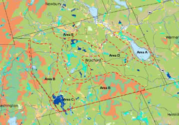 |
Example of priority areas identified by the town of Bradford using the Habitat Land Cover map for the town. Priority areas were selected based on: large unfragmented tracts (Area B), one of the largest peatlands in the state (Bradford Bog - Area C), important small scale habitats (peatlands, grasslands, marsh & shrub wetlands - Areas D and E), and pond habitat featuring a rare plant species, marsh and shrub wetlands and some undeveloped shoreline (Area A). |
| Highest Ranked Habitats Map and Associated Data |
- Locate the Highest Ranked Habitat map for your town. This map helps to identify where on the landscape a particular patch of habitat has good biological diversity (particularly in terms of rare species), is connected to other similar patches in the landscape, and is not highly impacted by people. This data can be used to help identify potential areas for conservation. Looking at the natural resources beyond your boundary is critical to protecting those within it. For more information on this map, look at the Habitat Condition page.
- Identify areas of highest ranked habitat in the state (pink) and highest ranked habitat in the region (green) and supporting landscapes (orange). These areas should be referenced when developing the Conservation Plan, the next step after the NRI.
- Using the Wildlife Habitats map, identify the critical habitats occurring within these pink and green areas.
- Review the map of prioritized habitats (see example and discussion above) and see if there are additional ranked areas that should be prioritized for wildlife conservation. These may coincide with the habitat priorities, expand habitat priority areas, or add additional priority areas.
- Note that the supporting landscapes (orange) are important to maintaining the integrity of the highest ranked habitats and should be included in any future conservation planning.
|
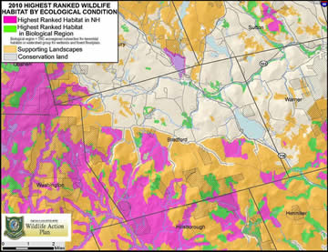 |
Highest Ranked Habitats and Supporting Landscapes in the town of Bradford. These areas corresponded closely with the priority habitat areas. Highest ranked habitats in the state are shown as pink, highest ranked habitats in the region are show in green, and supporting landscapes are shown in orange.
This map can help prioritize potential areas for conservation. |
| Next Steps - From Natural Resources Inventory to Conservation Plan |
- Incorporate the habitats map for your town with the priority areas marked on it into your Conservation Plan, the next step after your Natural Resources Inventory.
- Take a look at existing conservation lands shown on the maps and identify areas where conservation lands could be expanded and/or linked in order to protect these areas. These targets should be identified in the Conservation Plan.
|