What are Skid Trails?
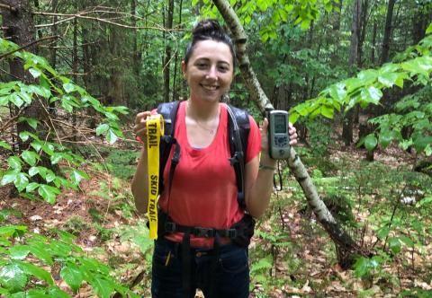
County Farm Woodlot Intern Brooke Gauthier here to report on my latest project!
What am I up to?
For the past 2 to 3 weeks I have been working with Carroll County Forester Wendy Scribner. We are working on marking a timber sale in a 30-acre white pine and hardwood mixed stand located off of Water Village Road in Ossipee, New Hampshire. Marking a timber harvest includes laying out skid roads, selecting what trees will be cut and, in this case, determining the amount of biomass leaving the forest. This operation is a whole-tree harvest meaning that the entire above-ground section of the tree is cut and removed from the forest.
What is a skid trail?
Skid trails, also known as skid roads, are temporary roads or trails used by logging equipment to remove logs from a timber stand. The equipment travels on the skid trails bringing the cut trees from where they were cut down to the log landing (the collection point for the cut wood). With some pre-planning and post-harvest clean-up, these roads can also help landowners move throughout their woodlot or provide means for recreation after the harvest is done.
Before marking the trails
Once the forester has a good idea where the area is that will be harvested, the log landing is located. Its location is important because it must be in an easily accessible location for trucks to load and haul timber off the site—so it should be near the timber and near a good public road. The landings can be an acre or larger, depending on the size of the operation, and must be large enough for a log hauling truck to be able to turn around. If there is no road or path to the stand that trucks can travel on, a road must be made.
Wendy Scribner had walked the stand and determined the location of the landing long before my internship took flight.
Skid trails converge onto the landing. Before the trails are marked, the land must be walked by a forester, allowing them to gauge any important geographic features of the land, such as vernal pools (season pools of water) or stone walls. This allows the forester to see the density of the trees within the stand, species composition and a rough estimate of timber quality. GPS coordinates are valuable assets in this stage because a forester can take points or track where they have walked, allowing them to upload the points to a GIS (geographic information system) software and look at the timber stand from an aerial view.
Aerial photos help plan the skid trail locations
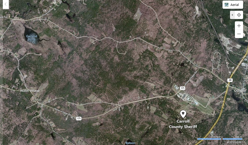
This is a google image of the timber stand, located north west of the Carroll County Sheriff's office above Water Village Road.

Here are GPS coordinates overlayed on an aerial photo of the forest stand.
Marking skid trails
This is where my internship comes into play! Using pink flagging tape and yellow "skid road" flagging tape, Wendy and I tied the tape to trees that the two main skid roads would go through. Generally, flagging is hung where the middle of the skid trail will be.

Me tying pink flagging tape to a tree to mark the skid trail (taken by videography intern Bridget Keaveney).
Challenges
Choosing where to place skid roads in the timber stand was very hard due to topographic challenges, such as elevation, stream-crossings and stone walls.
Elevation changes cannot be too drastic due to the size of the machinery. It will take a lot of gas and force to get skidders and feller-bunchers up a steep hill. Trails also cannot have sharp turns because logging equipment will be dragging 60 to 80 foot trees behind them.
Not all stands have a stream-crossing, but this harvesting operation does have a stream flowing through one of the skid roads. In order to get logging equipment across the stream, a temporary bridge will be put in. The bridge will be made from materials onsite, such as cut logs. Bridges should be placed in a straight area where the stream is not too wide to diminish erosion. Putting the bridge on a bend can cause too much erosion due to the stream current pulling away sediment in a now disturbed area. When dealing with these crossings, we follow Best Management Practices to protect water quality and stream health during the job.

Me looking at the stream that runs through the stand (taken by Bridget Keaveney).
This stand also has several stone walls (as shown in the map above). This is difficult to deal with because the stones must be moved to allow logging equipment through or the skid roads must divert away from the walls. Moving the rocks can be time consuming and labor insensive, while avoiding the walls can take skid roads away from sections of the stand that need to be cut.
Other activities
For two of my work days Cooperative Extensions videography intern Bridget Keaveney followed me around to get footage of the work I am conducting for a donor campaign. One of those days was doing the regeneration survey with Tim Fleury and the second day was marking skid trails with Wendy Scribner.
Related Resource(s)
Author(s)


