NH Coastal Viewer
SHARE
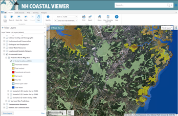
The New Hampshire Coastal Viewer is an online mapping tool that for the first time brings together new and existing hazards data in NH’s coastal watershed. Examples of this data include field-tested salt marsh data, floodplains, storm surge and sea-level rise information, infrastructure, and culvert data. Anyone with an Internet connection can access the Viewer to make customized maps for planning and educational purposes. Go to the Coastal Viewer