
The shorelines of rivers, streams, lakes, ponds and estuaries have significance for both wildlife habitat and water quality. As ownership of shorefront property continues to rise in popularity and shorelands become increasingly developed, the potential for pollution of water bodies and loss of wildlife habitat have become significant issue. The vegetation in undisturbed shoreland areas, also known as naturally vegetated buffers, or riparian areas slows surface runoff and promotes infiltration, reducing erosion and sedimentation in surface waters. These vegetated areas also reduce flood peaks during storm events, minimizing downstream flooding potential. They also provide valuable habitat, shelter, food sources and travel corridors for wildlife. River corridors are particularly important as spring and fall migration routes for birds. Species such as brook trout only inhabit cool, well-oxygenated water which occurs where sufficient shading by trees and other vegetation keeps solar energy from raising water temperatures during the day. Protecting undeveloped shorelines is an important strategy for developing resilience to climate change in the context of greater magnitude and intensity of precipitation events and mitigating flooding. For further information on the value of naturally vegetated shorelands, refer to the document Buffers for Wetlands and Surface Waters - A Guidebook for NH Municipalities.
The Shoreland Water Quality Protection Act (SWQPA) (RSA 483-B), originally named the Comprehensive Shoreland Protection Act (CSPA), was enacted by the 1991 session of the Legislature and amended in 2008. The act established minimum standards for the subdivision, use and development of the shorelands along the state’s larger waterbodies. During the 2011 legislative session, the CSPA was renamed the Shoreland Water Quality Protection Act and changes were made to the vegetation requirements within the natural woodland and waterfront buffers, the impervious surface limitations and a new shoreland permit by notification process was established. Shorelands protected by the SWQPA are those lands that are located within 250 feet (measured using a horizontal surveyors line) from the reference line of protected waterbodies. The bodies of water protected by the Act include all lakes, ponds and impoundments greater than 10 acres, all 4th order and greater streams and rivers, all Designated rivers and river segments under RSA 483 (The Rivers Management & Protection Act) and all waters subject to the ebb and flow of the tide (including tidal marshes, rivers and estuaries).
Basic NRI - What to Include:
Documenting undeveloped shorelands requires more detailed work and can be included as a Detailed Inventory Study (see below).
Detailed Inventory Studies:
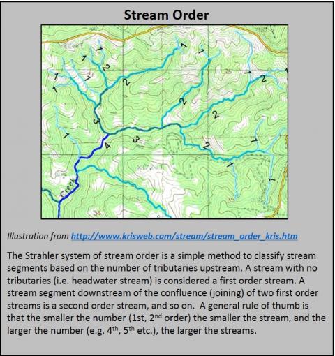
It is important to note that the Shoreland Water Quality Protection Act doesn’t give protection to first, second and third order streams or ponds less than 10 acres in size. The only protection these rivers and streams receive is through local regulation and voluntary land protection. For example, the Exeter River in southeastern New Hampshire is classified as fourth order only in the lower third of its length. The upper two thirds of the river, which has third and second order classification, doesn’t receive protection under the Shoreland Protection Act. The NH Rivers Program maintains a list of fourth order rivers in the state. Using aerial photography (available via GRANIT, GRANITView and the NH Wetlands Mapper), identify undeveloped shorelands in your community. Some field checking may be necessary, especially if the aerial photography is a few years old. This information could subsequently be digitized for inclusion in the inventory as GIS data layer. These areas can be shown on the water resources map or a separate map.
Additional Resources:
NH DES List of Fourth Order and Higher Streams
NH Statewide Map Atlas “Fourth Order and Higher Streams”