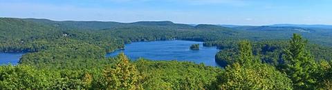
New Hampshire's 1,300 lakes and ponds cover about 280 square miles of the state's area. Over 10,000 miles of streams and rivers flow through the state. These waterbodies and their adjacent riparian (stream side) habitats provide important benefits to communities, including clean water, flood management and recreational opportunities. The health of NH's water resources is closely related to the health of our watersheds. A watershed is the area of land that contributes surface water runoff to a stream, river, lake, pond or other waterbody. Poorly planned development in a watershed can considerably increase the amount of stream water runoff, chemicals, sediment and other contaminants entering streams and waterbodies, threatening water quality, degrading habitat value and increasing flood risk. Precipitation has become more variable and extreme with climate change in New England, exacerbating these threats. Thorough documentation of streams and waterbodies in the NRI can help communities to plan for and mitigate future flood risk as these precipitation trends continue.
Protection of surface water resources and the lands associated with them is even more critical in the context of a changing climate. New Hampshire has already seen an increase in annual precipitation of 7-20% across the state since 1970, and the frequency and magnitude of precipitation events has increased. Annual average precipitation is projected to increase by 16-19% in New Hampshire by end-of-century. Larger increases are expected for winter and spring, exacerbating concerns regarding rapid snowmelt, high peak stream flows, and increased flood risk. New Hampshire can also expect to experience more extreme precipitation events in the future. For example, under a high emissions scenario, events that drop more than four inches of precipitation in forty-eight hours are projected to increase two- to three-fold across much of New Hampshire by the end of the century.
Basic NRI Elements
Rivers, streams, lakes and ponds in the study area can be mapped and described using the NH Hydrography data set in GRANIT (GIS Users), the Water Resources data layers in GRANITView and more detailed local sources where available. This information can be displayed together with watershed boundaries (available in GRANIT and GRANITView). Watersheds provide logical units for evaluating surface water resources since issues such as water quality and water quantity extend beyond political boundaries. Other optional surface water datasets that are readily available and could be included in the inventory include:
Designated Rivers: A river designated under the New Hampshire Rivers Management and Protection Program is managed and protected for its outstanding natural and cultural resources in accordance with RSA 483, The Rivers Management & Protection Act. it also includes the map of state-designated rivers in NH. Two rivers in New Hampshire (sections of the Lamprey and Wildcat Rivers) are designated under the National Wild and Scenic Rivers Program. Designated Rivers form an important component of the ecology of that river system.
Dams: NH Department of Environmental Services maintains a database of all dams registered with the state. The data are complete as of the publication date. Updates and/or changes are made continually. The data is available on both GRANIT and GRANITView
Wetlands data is available via the National Wetlands Inventory Maps and Hydric soils - this data is available on both GRANIT and GRANITView. Refer also to the NH DES Wetlands web page for additional resources and information about wetlands.
Detailed NRI Elements
Buffers for Surface Waters: GIS mapping tools can also be used to map buffers of different widths adjacent to water bodies and perform a number of related distance, acreage, and other measurement calculations. For example, if a community were considering adopting a 50- or 100-foot wetlands setback requirement for certain land uses, the GIS database could be queried to determine which areas would be impacted, and how much acreage those areas represented. A person experienced in using GIS would be needed to conduct this analysis. Refer to the website Buffers on the Bay for more information about buffers (applies to inland buffers too).
Wetlands Inventory and Identification of Prime Wetlands and associated resources can be found on the website Method for Inventorying and Evaluating Freshwater Wetlands in NH (NH Method). Use the NH Method to conduct a functional assessment of wetlands in your community or evaluate Prime Wetlands.
Surface Water Quality Studies are available from several sources, described below. There may also be other local water quality assessment efforts that could be incorporated into a detailed NRI study. In NH, water quality data is collected by citizen volunteer groups for several programs, such as:
New Hampshire Lakes Lay Monitoring Program (LLMP) is a group of scientists, students, researchers and volunteers dedicated to preservation and sound management of lakes through citizen-based monitoring and student-based research.
NH DES Volunteer Lake and Rivers Assessment Program are volunteer programs that assists DES in monitoring water quality.
Additional Resources
NH Water Resources list of publications and websites
NH Source Water Protection Grants program assists in the protection of community drinking water supplies by providing grant funds for the acquisition of land or conservation easements.
NHDES Source Water Protection Program provides information about maintaining and regulating safe drinking water supplies (wells and surface waters) Municipalities and water suppliers have a key role in managing land uses that affect drinking water quality.