U.S. Department of Agriculture
Forest Service
Northeastern Forest Experiment Station
NE-INF-37-79
The information in this brochure was prepared by:
William B. Leak, silvicultural research scientist at the Northeastern Forest Experiement Station’s Forestry Sciences Laboratory in Durham, New Hampshire
Jane R. Riddle, public information specialist with the Northeastern Station’s Information Services office in Broomall, Pennsylvania.
Illustrations are by New Hampshire artist Marilyn Collins.
Introduction
About 10 to 15,000 years ago, the small vertical strip of North America that would someday be New Hampshire was just emerging into the post-glacial dawn. Vegetation that had been pushed south by the icy advance was slowly moving north to reclaim land relinquished by the glacier.
The melting ice revealed many changes in the earth’s surface. Mountains were rounded off, rocks were cracked and buried and ground down. Where before one tree species would have flourished, another took root.
Soon, the history of the glacier would be revealed as much by the vegetation that replaced it as by geologic evidence. The type and arrangement of plants would always serve as a mirror for the mixture of clay, silt, sand, and rock lying beneath them. And the explanation for why certain species grow where they do, and why they grow better in some places than in others, could always be found right in their own backyard.
Knowing that trees differ in their requirements for nutrients and moisture, and that sites differ in their ability to supply these needs, we can correlate species to habitat and produce descriptions of various typical combinations. Using this knowledge, foresters, land-owners, and interested laymen can identify tree habitats by examining the topography and the soil materials that lie beneath the surface.
In this brochure, we give you the basic information and outline the steps used to identify tree habitats in New Hampshire. Our main emphasis is on areas with soil derived from granitic bedrock. The research which produced this information was conducted in the glaciated mountains of New Hampshire by scientists with the USDA Forest Service, Northeastern Forest Experiment Station. Similar habitats can be found in glaciated areas where the climate and the bedrock are different, but the typical species you find there may differ as well.
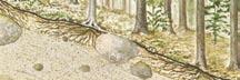
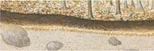
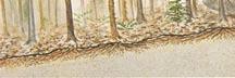
Soil Profile
The topmost layer is Litter, and is composed mainly of twigs and leaves.
Next is Humus, a black organic matter formed from decomposing litter.
Beneath the humus there often lies a white leached layer designated A2.
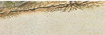
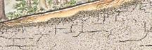
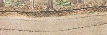
One layer down, the B Horizons begin. The “B’s” are red, brown, and yellow layers of soil transpierced by tree roots.
At rock bottom are the C Horizons, gray and yellowish layers not yet penetrated by tree roots.

For our purposes — identifying tree habitats — the most important layers in the soil profile are the B and C horizons. Habitat descriptions are based on the evaluation of four factors: water relations and enrichment in the B horizons; and particle sizes and compaction in the C horizons.
Let’s look first at water relations in the B horizons. These can be any of three characteristic conditions:
Dry: You’ll see no evidence of standing or moving water, and no gray, olive, or rusty mottled areas that indicate excess water.
Moist: Look for water or mottles in the mid to lower B horizons.
Wet: These will be flat, wet areas where the B horizons are gray or heavily mottled.
The next distinction to make in the B horizons is the presence or absence of enrichment. Determine which of the following descriptions best fits the location you are examining:
Enriched: areas include coves, benches or other places where deposits collect. The B horizons here are dark brown due to heavy organic matter content. Very often, the A2 horizon is either absent or just barely in evidence. The soil can be either dry or moist.
Nonenriched: soil has average B horizons, where you’ll see no strong evidence of added organic matter.
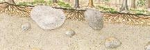
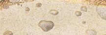
In the C horizons, you should first determine which soil particle size or sizes are present. The three basic classifications are:
Rock or Rocks: Consolidated soil material.
Gravel and Sand: Coarse particles; individual particles can be seen with the naked eye.
Silt and Clay: Fine particles; individual particles cannot be distinguished by eye.
You’ll find that some soil materials consist primarily of one size particles. For example, glacial outwash areas contain mostly sand and/or gravel. Soils classed as sediments hold mostly silt and/or clay, with some very fine sand mixed in. Other soils, such as glacial till, contain a mixture of all particle sizes.
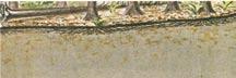
The second characteristic to consider in the C horizons is the amount of compaction. C horizons may be either:
Compacted, in which case it will be a hard layer that looks like many interlocking plates. You will have difficulty digging here. Stones will be firmly embedded, especially when the soil is dry. The soil will be hard enough to support free-standing water, although you may not actually find water there.
or Noncompacted, which means you will be able to dig into the soil without much difficulty. The soil here won’t be much firmer than that in the B horizons, and will be permeable to water.
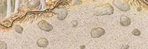
Don’t confuse compaction in the C horizons with the red-brown-blackish cementation you’ll sometimes find in the upper B horizons.
Based on these criteria, we have identified nine habitats in New Hampshire forests. Certainly more exist, but for now we will consider these nine basic types:
1. Poorly drained
2. Rock
3. Outwash
4. Moist compact till
5. Dry compact till
6. Lake sediments
7. Washed till
8. Fine till
9. Enriched
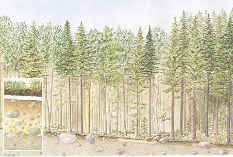
Poorly Drained Habitat
Wherever a poorly drained habitat now stands, a swamp once existed in the wake of the glacier. Water still lends these areas their distinguishing features. The land is usually flat and wet, with obvious pools of water on the surface. Ferns and other plants that like or tolerate water are often found here in abundance. The trees are shallow-rooted and may blow over easily. Logging may be difficult on poorly drained areas, except in the winter or in very dry seasons, because the equipment tends to sink into the ground.
Characteristics: Flat areas; grey or mottled subsoil.
Species: Red spruce, hemlock, balsam fir, red maple, and birches in young stands; red spruce and hemlock in old stands.
Growth: Slow for softwoods and hardwoods.
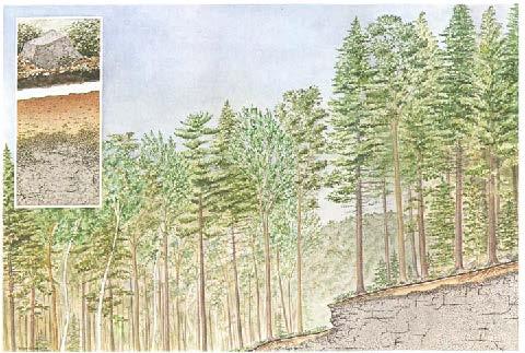
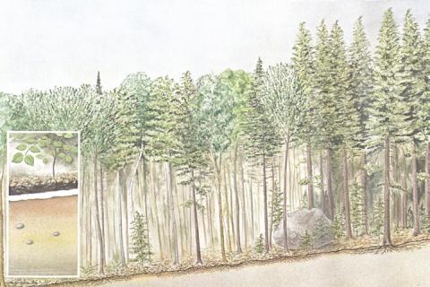
Rock Habitat
As the glacier passed through areas now cIassified as rock habitat, it scraped over the bedrock, tearing away some large fragments and leaving little or no soil in its wake. The rock fragments torn loose by the glacier were dropped nearby before they could be worn smooth, so the area is punctuated with square or sharp- angled rocks. At these frequently higher eIevations, blueberry bushes are a common sight. They grow especially well in openings in the forest. Because of the scarcity of soil, there is a tendency for trees to blow over easily here. Another type of rock habitat is found at lower eIevations, where a bed of boulders is all that remains after some prehistoric stream or river swept away the soil.
Characteristics: B horizons shallow with coarse rock fragments; underlain with bedrock, rock fragments, or stones. Occasional rock ledges at surface.
Species: Red spruce, hemlock, red maple, birches, occasional oak in young stands; red spruce and hemlock in old stands.
Growth: Slow for softwoods and hardwoods
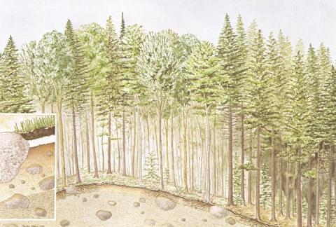
Outwash Habitat
The quintessential outwash habitat is a sand or gravel pit. Such an area is a sink for soil material deposited in the wake of streams and rivers formed by melting glacial ice. Coarse particles — sand and gravel — will settle first, while fine particles — silt and clay — travel further downstream. Outwash habitats usually occur at medium to lower elevations. Blueberries often adapt better than other plants to this coarse, dry soil.
Characteristics: C horizons predominantly sand and gravel; few surface boulders; buried stones appear clean and washed; flat to rolling topography.
Species: Red spruce, hemlock, white pine, red maple, birches in young stands; spruce, hemlock, and a few white pine in old stands.
Growth: Medium for softwoods and hardwoods; white pine most productive species.
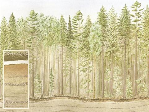
Moist Compact Till Habitat
Subjected to thousands of tons of glacial pressure, the compact C horizons, undisturbed by tree roots, were pressed into one tightly packed layer that now forms a watertight barrier on moist compact till habitats. The tremendous pressure can be more vividly imagined when one considers that the ice was almost a mile thick in places. Even the boulders that escaped the glacier’s hold were pressed into the soil so that only their topmost layer shows above the surface. Because of the wet soil, gullies form easily here and loggers sometimes find it hard to build and maintain roads or trails.
Characteristics: Glacial till; hard, compact C horizons; some mottling and/or water in B horizons; topography flat or depressed; surface boulders level with or pressed into surface.
Species: Red spruce, hemlock, red maple, birches in young stands; hemlock and red spruce in old stands.
Growth: Medium for softwoods and hardwoods.
Dry Compact Till Habitat
It is tempting to think of dry compact till habitats as just moist compact till areas without the water, but the situation may not be that simple. Some scientists believe that soil there may be held together by a chemical cementing agent. But they also recognize the part possibly played by the great weight of the glacier in compacting the C horizons into hard, platy layers. These habitats often go incognito, since on the surface they resemble many other areas. Their identity becomes obvious when a probing shovel or spade encounters the impervious C horizons.
Characteristics: Glacial till; C horizons hard and platy; stones difficult to dislodge; no evidence of water or mottling; topography rolling, ridge-like, or convex.
Species: Red maple, beech, birches, red spruce, hemlock in young stands; hemlock and red spruce in old stands.
Growth: Medium for softwoods and hardwoods.
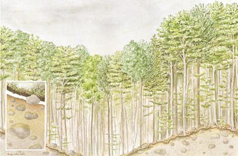
Lake Sediments Habitat
Picture a cool, still lake surrounded by slowly melting ice. Mist forms on the surface as water evaporates into the warmer air. At the lower end of the lake, a temporary ice dam detains the meltwater on its way to becoming a stream or river. Fine particles of sand and silt drift lazily toward the bottom of the lake.
Millions of years later, early settlers found these lake sediment habitats, being fairly free of rocks, to be ideal places for farming. Pure sediments like this are not too common in mountainous regions. The smooth layers of sand or silt are interrupted only occasionally by a larger boulder. Perhaps it floated across the lake on an ice barge, and then settled to the bottom in a cloud of silt.
These habitats are usually found at lower elevations, in valleys or ravines where a stream or river follows the ancestral path.
Characteristics: C horizons are uniform fine sand and silt; loose and dry (sandy sediments) or moist and sticky (silty sediments); few stones; topography flat to gently rolling.
Species: Red maple, beech, birches, red spruce, hemlock in young stands; hemlock and red spruce in old stands.
Growth: Good for softwoods and hardwoods.
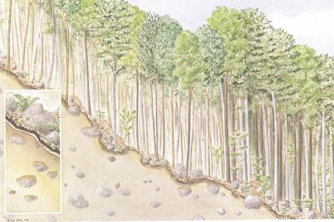
Washed Till Habitat
Like a Grim Reaper of soils, the glacier gathered everything in its path, and then scattered it like so much chaff. Where glacial melt formed a river, stream, or lake, soil was sorted into layers of particles of different sizes. Areas classified as washed till habitats were merely rinsed by water, so that much of the finer material was swept away. The remaining soil came to rest as the glacier melted. These habitats occur most often at lower elevations.
Beech trees take to washed till like a bee to honey . . . or like a bear to beech nuts. The furry mammals will climb a tree many times to gorge themselves on the succulent nuts, and leave abundant claw marks as evidence of their forays. Deer are also fond of this forest food.
Characteristics: Glacial till but very little silt and clay; loose, sandy material; buried stones are dirty or silt-capped; rolling topography with a few surface stones.
Species: Beech, red maple, birches, a few softwoods in young stands; beech abundant in old stands.
Growth: Good for hardwoods; softwoods not too common.
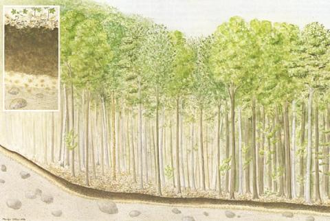
Fine Till Habitat
Fine till habitats might be called the dustbin of the glacier. Everything that has been picked up along the way was unceremoniously dumped here with little if any washing or sorting. The land is often steep and irregular. Fine till is probably the most common habitat in the mountains of New Hampshire.
Characteristics: Glacial till with all particle sizes; firm, not loose; irregular topography and numerous surface stones.
Species: Beech, sugar maple, yellow birch common in young stands.
Growth: Very good for hardwoods; softwoods uncommon.
Enriched Habitat
In certain coves or benches in the New Hampshire forests, leaves and fine particles of soil have washed in year after year and turned the glacial till into a sort of compost pile. The soil in these enriched habitats is often so laden with organic matter that the layers lose their identity, merging into material resembling a rich potting soil. On these small but fertile areas, trees grow extremely well.
Characteristics: Topography is a cove or bench; B horizons brown; soil layers or horizons indistinct; A2 horizon usually missing; moving water sometimes present; C horizons usually fine till or compact till.
Species: Sugar maple, white ash, miscellaneous species in young stands; sugar maple, some beech in old stands.
Growth: Very good for hardwoods; softwoods not common.
When you take your knowledge of habitats to the field, use the following suggestions to aid in the process of identifying habitats:
1. When deciding on the boundaries of an area you wish to identify, look for uniform forest and topographic conditions. The size can range from a few to many acres in size.
2. Softwoods tend to be more prevalent in areas that have been farmed or used for pasture than in similar unpastured areas. To determine whether an area was once farmed, look for evidence of old roads, stonewalls, and cellar holes.
3. If you can, determine what type of bedrock is prevalent in the area. Soil materials derived from rocks such as schist tend to support more hardwoods and faster-growing stands than those derived from granite.
4. Dig several pits, or take advantage of places where the soil profile has been exposed, such as road cuts or excavations. Examine the pits or road cuts to a depth of about three feet. Note the tree species and the topography, and determine whether the stand is young or old.
5. For a final identification, use the descriptions in this brochure. Make sure that the characteristics of topography, soil materials and species composition point toward the same habitat. Remember that some areas are best described as a combination of two or more habitats.
More information on identifying habitats is available in the following publications:
Relation of tolerant species to habitat in the White Mountains of New Hampshire.
USDA Forest Service
Research Paper NE-351.
Relationship of species and site index to habitat in the White Mountains of New Hampshire.
USDA Forest Service
Research Paper NE-397.
Relationship of forest vegetation to habitat on two types of glacial drift in New Hampshire.
USDA Forest Service
Research Note NE-257
This document has been reformatted - February 2007.
Contact
