
Science notebooks have been used by scientists throughout history to document their work in the field and laboratory. Scientists fill these notebook pages with data measurements, detailed observations of a study location and important activities related to their investigation. In many scientific professions, the scientist maintains a notebook for each project or study carried out.
Today’s K-12 learners are expected to think and act as scientists to investigate real-world natural phenomena. Creating a science notebook with young scientists is one starting point for exploring natural phenomena within a schoolyard, backyard and community.
The materials required to create a science notebook are minimal. The format is flexible to accommodate a range of scientific endeavors and explorations for many ages and learners. Providing learners with a focus or prompt helps them notice the all-too-often unnoticed parts of the natural world. This can lead to new ways of seeing and understanding the complexities of the natural environment by using a keen eye and a sense of wonder.
Similar to professional field scientists, in this Outdoor Explorer Activity, young scientists will start a science notebook of their own and select an outdoor area to observe in detail and map.
MATERIALS:
-
Booklet with blank or unlined pages
-
Pencil
-
Air thermometer or weather app downloaded onto a handheld device
-
Beaufort wind scale (see Beaufort scale resource)
-
Compass or compass app downloaded onto a handheld device
-
Optional: clipboard, colored pencils, camera, hand-lens or magnifying glass, binoculars, field guides, ruler
SAFETY NOTE: During the COVID-19 public health crisis, make sure the outdoor area used for this activity maintains CDC’s social distancing recommendations.
TEACHER NOTE:
For Students in Grades 3rd-5th (with appropriate modifications)
Next Generation Science Standards (NGSS)
Disciplinary Core Idea--Life Science:
-
Observe the parts of either a plant or animal in your yard. (1-LS1, 4-LS1, 5-LS1)
-
Investigate the components of the ecosystem in the yard. (2- LS2.A, 5-LS2.A)
NGSS Science Practices (SP):
-
SP1: Asking questions
-
SP2: Developing and using models
-
SP3: Planning and carrying out investigations
-
SP4: Analyzing and interpreting data
-
SP6: Constructing explanations
CREATE A SCIENCE NOTEBOOK:
-
To start your own science notebook either make* or obtain a booklet with blank or unlined pages. (To make your own booklet, fold and staple together 8-10 blank pages.)
-
Decorate the cover of the booklet to personalize it.
-
Print the Beaufort scale, sizing appropriately for your science notebook, and paste/tape onto the first page. (If a printer is not available, create your own copy of the Beaufort Scale.) You are now ready to use your science notebook to observe an outdoor area.
SELECT AN OBSERVATION AREA OF INTEREST:
-
Select a specific area that particularly interests you to focus your observations. If possible, select a large enough area that includes some noticeable variety in the natural environment—plants and wildlife or wildlife signs. (If necessary, you can also observe an outdoor area from a window with a good view outside.)
-
Notice the boundaries of your area and ask yourself ‘where does the area begin and end?’
Example: My observation area extends from the woods to the playground on one side and the lawn on the other side.
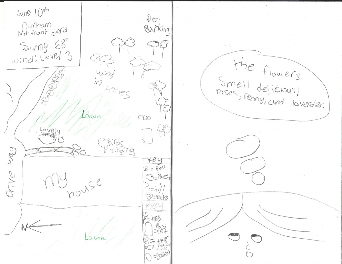
RECORD IMPORTANT DAILY INFORMATION:
1. For your first notebook entry as an Outdoor Explorer (and for all future entries too), record the following daily information (start on approximately page five of the notebook to leave some blank pages at the front for additional resources in the future):
- Date
- Location
- Weather description including sky color, air temperature and wind speed (see Beaufort Scale)
MAKE A MAP:
-
Make a map of your observation area from a bird’s-eye view. A map is a simple model and is meant to represent something that is much larger in reality.
-
Using a pencil, sketch a simple map illustrating your observation area. Focus on the locations of the main features and do not focus on making the map to scale. Use symbols to illustrate the parts and include a key showing what each symbol represents (e.g., triangle = wooded area, oval = vegetable garden, rectangle = bird feeder).
NOTE: It can be helpful to draw the outside boundaries first and then add what’s contained within the boundaries second.
-
With a compass (or compass app on a handheld device) determine where North is located and draw a North arrow on the map.
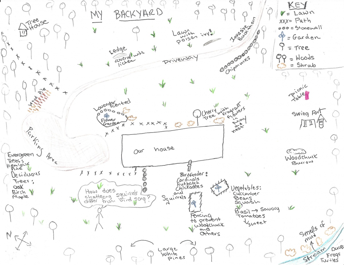
RECORD OBSERVATIONS:
-
Use your senses (at least two) while observing your area and annotate your map with notes.
- What do you hear?
- What do you see?
- What do you smell?
- What is the texture of a nearby plant (bark of tree or shrub)?
-
Label all the main features (e.g., shrubs, lawn, swing set, garden, evergreen trees) with words or symbols from your key.
-
What do you notice about your area? What new questions do you wonder? Write one new idea, realization or question about your observation area as a “thought bubble” on your map or a new page.
CREATE A SEARCH-AND-FIND & CHALLENGE A FRIEND:
-
On a separate piece of paper, write three brief, descriptive clues for three different features (e.g., pine trees, garden, stonewall) on your map. Words such as “near,” “next to,” “between” and “far” can help to describe locations of map features.
Example Clue: The part I am thinking of is near the pine trees and across from the vegetable garden and is often visited by squirrels. What is this map feature?
-
Share (either in-person or remotely) the three clues with a partner and provide a copy of your map.
-
Challenge your partner to find these locations in your actual schoolyard or backyard or on the map itself.
-
How did your partner do?
-
OPTIONAL: Try again with a new set of clues or use your partner's clues to locate features on your partner's map.
Further Exploration:
-
For additional ways to continue as an Outdoor Explorer, see the UNHCE website for several ideas including seaside explorations, close-up views of garden flowers and testing the buoyancy of objects in your home.
Additional Resources:
How Science Notebooking Can Support Meaningful (and accessible) Science Learning. (2020, March 21). Retrieved June 17, 2020 from https://www.ngssphenomena.com/ourvoice/2020/3/20/sciencenotebooking.
Leslie, C.W. (2015). The curious nature guide. North Adams, MA: Storey Publishing.