DOVER • DURHAM • EXETER • GREENLAND • MADBURY • NEWFIELDS • NEWINGTON • NEWMARKET • ROLLINSFORD • STRATHAM
This fact sheet summarizes guidance and voluntary actions that Great Bay municipalities can take to prepare for projected changes in storm surge, sea level, and precipitation. Content is provided from the 2016 NH Coastal Risk and Hazards Commission (CRHC) Final Report and Recommendations. Visit www.nhcrhc.org for more information.
6 Tips to Guide Action
- Act Early. Start planning now. Being proactive will save money in the long run when compared to a more traditional reactionary approach to flood management.
- Respond Incrementally. Take manageable steps to prepare over the long run.
- Revisit and Revise. As the science improves, adjust your approach to match expected conditions.
- Collaborate and Coordinate. Work together across sectors and with neighboring municipalities to maximize impact.
- Incorporate Risk Tolerance in Design. Design projects based on willingness to accept risk associated with unacceptable performance. Risk tolerance will likely vary based on the importance and cost of maintaining or replacing a structure.
- Make No Regrets Decisions. Take actions that offer multiple benefits to your municipality, and will therefore provide added value regardless of the flood scenario that occurs.
Specific Actions Municipalities Can Take to Prepare
GET FUNDING AND PROVIDE INCENTIVES
- use existing funding sources such as FEMA mitigation grants, the NH Aquatic Resource Mitigation Fund, private foundations, land acquisition and easement programs, and state and federal grant opportunities
- create a dedicated fund to acquire repetitive loss or high flood risk properties
- establish stormwater and flood mitigation utilities to fund retrofits
- establish tax credits and revolving loan funds that discourage development in high-risk areas
- consider joining the National Flood Insurance Program’s Community Rating System, which provides discounts on annual flood insurance premiums for some residents and businesses
Key CRHC Recommendations: CC1, CC6, CC7, E3, NR3
REACH OUT
- contact the NH Coastal Adaptation Workgroup for outreach and assistance with preparing for coastal hazards
- improve consumer protection disclosure of vulnerable properties and distribute flood protection safety information to property owners in high-risk areas
- encourage eligible and moderately vulnerable homeowners to purchase Preferred Risk National Flood Insurance Program policies
- encourage private property owners and businesses to incorporate vulnerability information in preparedness plans
Key CRHC Recommendation: E4
ASSESS VULNERABILITIES
- conduct site-specific vulnerability assessments for priority public assets
- evaluate deficiencies and barriers in municipal regulations, plans, and policies
- assess vulnerability of economic assets, including tax base, workforce and jobs, property values, insurance costs, trade facilities, and public recreational facilities
- assess opportunities to improve regional emergency services, evacuation routes, and emergency communication systems
- map the plausible future changes in freshwater and coastal floodplain extent
Key CRHC Recommendations: CC2, E1, BL1, BL3, H1, H3
PLAN AHEAD
- incorporate vulnerability assessment information in hazard mitigation plans, coastal hazards or climate change adaptation Master Plan chapters, emergency management plans, capital improvement plans, and response and recovery plans
- identify and reduce inconsistencies between municipal plans and state plans
- prepare watershed-based plans and water resources management plans that consider projected changes in hydrology
- create plans to adapt or relocate vulnerable cultural and historic buildings
- develop municipal inventories of land available for conservation in areas that reduce flooding and promote the migration of species and habitats
Key CRHC Recommendations: CC7, E2, NR2, NR3, NR4, H4
REGULATE
- create and encourage adoption of local flood hazard overlay districts that include higher development standards
- implement freeboard standards above the Base Flood Elevation; consider two feet of freeboard for non-critical structures and facilities and three feet for critical structures and facilities
- consider prohibiting development or implementing voluntary transfer of development rights in areas destroyed by storms, experiencing repetitive loss of structures, and subject to chronic flooding and erosion
- consider adopting buffers and setbacks that better account for vulnerability of structures, facilities, and natural resources and maintain ecosystem services (e.g., flood storage and storm surge attenuation)
- require implementation of stormwater best management practices and low impact development management systems to minimize impacts and maintain aquatic habitats
Key CRHC Recommendations: CC6, CC7, BL2, BL4, NR3, NR4
INVEST & IMPLEMENT
- improve management, coordination, and delivery mechanisms to ensure continuity of services to essential facilities, people, businesses, and employment centers
- remove or modify vulnerable structures and facilities that create barriers to tidal flow and habitat migration
- minimize shoreline hardening and promote natural or living hybrid shoreline protection strategies
- restore and protect coastal dune systems that provide protection from storm surge and erosion
- protect salt marsh migration areas
- elevate vulnerable properties
- acquire vulnerable and repetitive loss properties to create flood storage areas
Key CRHC Recommendations: CC6, NR2
Need help getting started? Visit the New Hampshire Coastal Adaptation Workgroup (CAW) at www.nhcaw.org or contact your regional planning commission: Rockingham Planning Commission, 603-778-0885, or Strafford Regional Planning Commission, 603-994-3500
Want to check your vulnerability? You can explore maps of sea-level rise and storm surge scenarios together with local asset data on the NH Coastal Viewer at http://nhcoastalviewer.unh.edu/. Look for sea-level rise scenarios in the “Oceans and Coasts” data folder.
Guidance for Preparing Using Risk Tolerance
SEA-LEVEL RISE
- Determine your project’s risk tolerance and identify its intended lifespan.
- If the project has a high tolerance for flood risk, commit to accommodate the intermediate-high sea-level rise scenario and be prepared to manage to the highest sea-level rise scenario.
- If the project has low risk tolerance, commit to accommodate the highest sea-level rise scenario.
- Be aware that projected sea-level rise may change and prepare to adjust project design considerations, if necessary.
STORMS
To prepare your project for coastal storms, add the appropriate sea-level rise scenario to current base flood elevations for the 100-year/1% annual-chance-flood and the 500-year/0.2% annual-chance-flood.
PRECIPITATION
Design projects to manage a 15% increase in rainfall produced during extreme precipitation events after 2050.
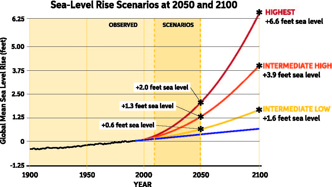
Example: The Town of Anywhere is building a new bridge, which has a low tolerance for risk due to its critical function in emergencies and is designed to serve the town until 2070. The bridge is designed to accommodate sea-level rise on the highest scenario curve for the year 2070, which is approximately 3.75 feet above 1992 sea levels.
By the Numbers: Changes in Sea-Level, Storm Surge, and Precipitation
SEA-LEVEL RISE
Using 1992 sea levels as a baseline, NH sea levels are expected to rise 0.6 to 2.0 feet by 2050 and 1.6 to 6.6 feet by 2100. The figure to the right shows potential future sea-level rise based on a range of greenhouse gas emissions scenarios.
STORM SURGE
Storm surges occur when winds from Nor’easters or sub-tropical storms drive ocean water toward land, resulting in a short-term rise in water levels. There continues to be uncertainty associated with projected changes in frequency and magnitude of Nor’easters and sub-tropical storms. However, as sea levels rise and coastal development expands, the potential flood damage associated with these storms will increase.
ANNUAL PRECIPITATION
Annual precipitation between 2071 and 2099 is expected to be as much as 20% greater when compared to the late 20th century. The Northeast is expected to experience more precipitation in winter and spring and less in summer and fall.
EXTREME PRECIPITATION
Extreme events are defined as the largest 1% of 24-hour precipitation events in a year. Extreme precipitation events are expected to increase in frequency and amount of precipitation produced, but current climate models cannot accurately predict precise changes in the frequency or magnitude of these events.

By the Numbers: Vulnerability in the Great Bay Municipalities
In all ten Great Bay municipalities, people and assets, including local economies, natural resources, infrastructure, and recreational and historic resources, face increased coastal flood risk in the future.
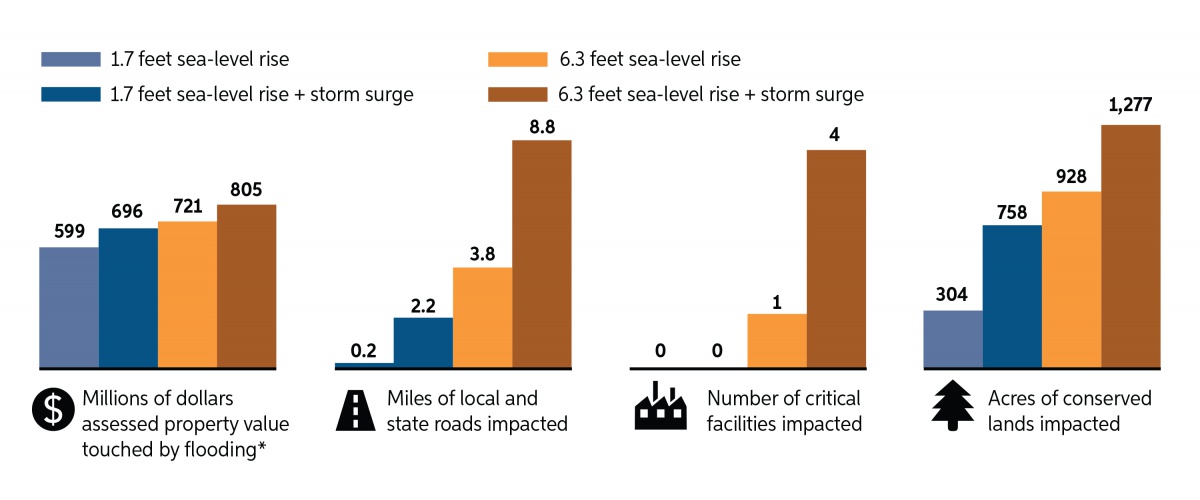
*Dollar values do not reflect projected cost from flood scenarios, but rather the assessed value of properties exposed to any amount of flooding
Source: C-RiSe 2017 (maps for each community available on the Rockingham Planning Commission and Strafford Regional Planning Commission websites)
Photo by Kyle Pimental; content developed by the NH Coastal Program, in collaboration with UNH Extension and others, for the NH Setting SAIL project
Contact
