Assessing the effectiveness of best management practices on timber harvests in New Hampshire

by Karen P. Bennett, Extension Forester, UNH Cooperative Extension, karen.bennett@unh.edu
A field note is a report from "the field," based on observation and experience. The field work and data analysis for this field note was funded through the Joint Chiefs Landscape Restoration Partnership Project. Partners include the Natural Resources Conservation Service (NRCS), N.H. Division of Forests & Lands, U.S. Forest Service—White Mountain National Forest (USFS-WMNF) and Northeast Area, State & Private Forestry and UNH Cooperative Extension.
 This project sought to answer the question, “When BMPs are used, do they effectively protect water quality on state and private lands in the project area?”
Probably the greatest change in practice I’ve seen in the nearly forty years I’ve practiced forestry in New Hampshire is the widespread use of Best Management Practices (BMP) during timber harvesting. BMPs are so ubiquitous that it is hard to fathom the days when they didn’t exist.
My eyes and my guts tell me when BMPs are used on logging jobs, they are effective and this study undertaken in 2015 and 2016 confirms that.
The project area
Because of the funding source, we looked at timber harvests on state and private lands in towns with part of their watersheds abutting the White Mountain National Forest.
Towns in the project area
Albany, Bartlett, Bath, Beans Grant, Beans Purchase, Benton, Berlin, Bethlehem, Campton, Carroll, Center Harbor, Chandlers Purchase, Chatham, Columbia, Conway, Crawfords Purchase, Cutts Grant, Dalton, Dixville, Dorchester, Dummer, Easton, Eaton, Ellsworth, Ervings Location Franconia, Gorham, Greens Grant, Groton, Hadleys Purchase, Hales Location, Hart's Location, Haverhill, Holderness, Jackson, Jefferson, Kilkenny, Lancaster, Landaff, Lincoln, Lisbon, Littleton, Livermore, Low & Burbanks, Lyman, Madison, Martins Location, Meredith, Milan, Millsfield, Moultonborough, Northumberland, Odell, Ossipee, Piermont, Pinkham's Grant, Plymouth, Randolph, Rumney, Sandwich, Sargents Purchase, Shelburne, Stark, Stratford, Success, Sugar Hill, Tamworth, Thompson & Meserve, Thornton, Warren, Waterville Valley, Wentworth, Whitefield, Woodstock
Developing the monitoring protocol
We adapted two BMP monitoring protocols used in the northeast:
- A Regional Protocol for Monitoring BMP Implementation and Effectiveness on Timber Harvest Operations by Roger Ryder and Tim Post of the Maine Forest Service and Dave Welsch of the U.S. Forest Service
- Forest Ranger Water Quality Inspection Handbook—Maine Forest Service
 Using these two documents we developed Monitoring Protocol for the Two Chief’s Water Quality Project adapted by Karen P. Bennett, Alicia Carlson and Sarah Smith, UNH Cooperative Extension, June 2015 which focused the fieldwork to New Hampshire and adapted the survey questions for direct input into hand-held devices. We uploaded the field results into a Qualtrics survey program and used Qualtrics to generate summary information.
Monitoring protocol philosophy
The protocol uses the following principles of water resources protection as the basis of evaluation:
- Plan the operation.
- Control water flow.
- Stabilize disturbed soils.
- Manage potential chemical pollutants.
- Minimize biological impacts.
 Evaluation of effectiveness is based on the above principles not the individual practices.
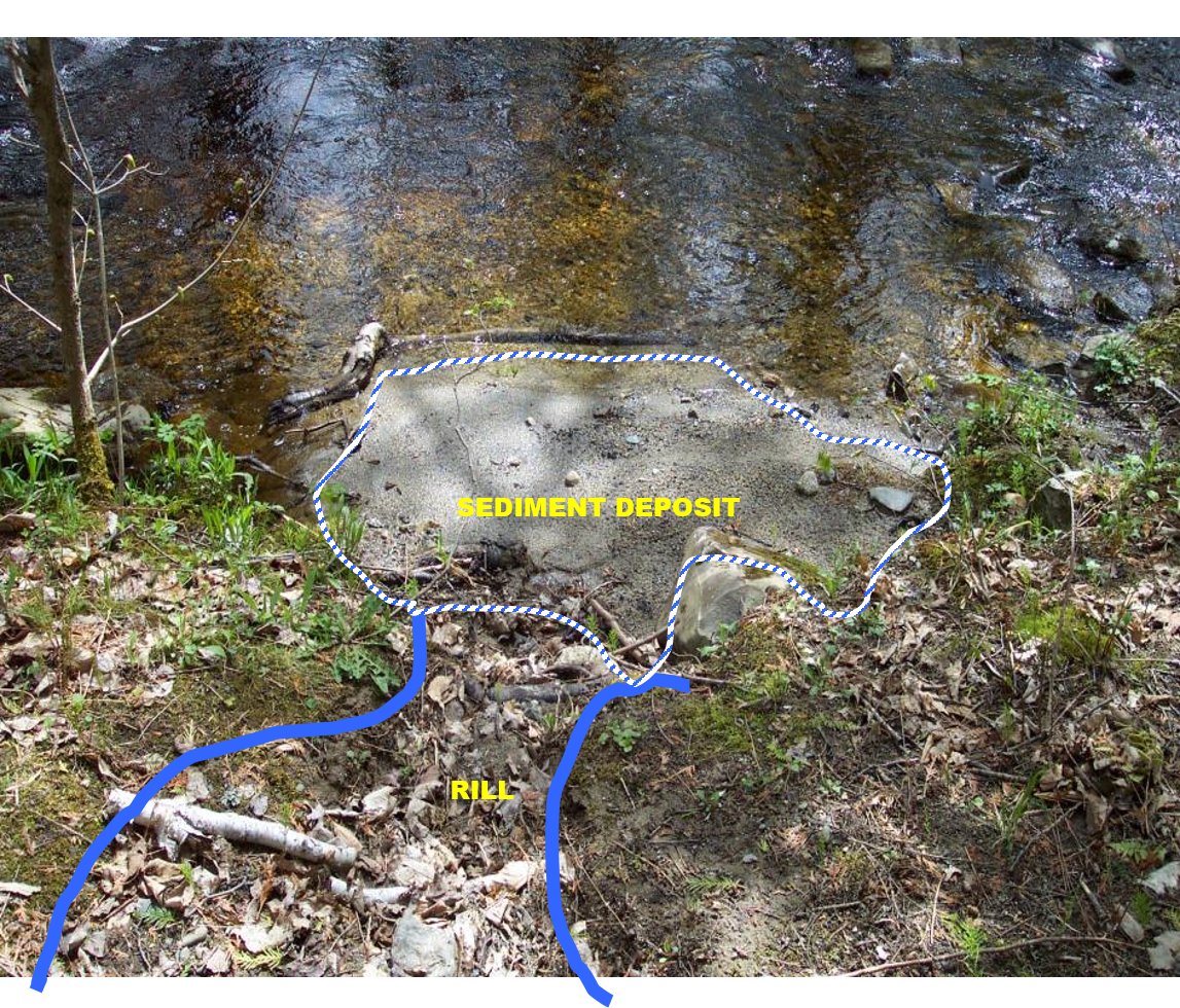
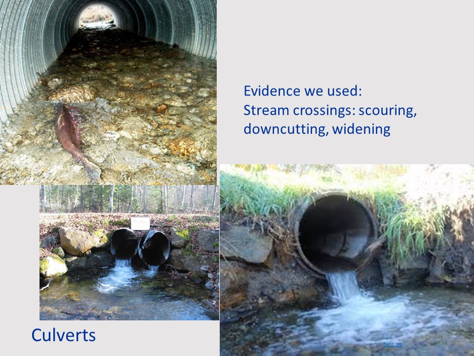
For example, controlling water flow is the principle and the BMPs used to control water flow include water bars, diversions, cross-drainage culverts and broad-based ditches. The protocols didn’t call for determining if the right BMP was used or in evaluating the BMP itself but rather the effectiveness regardless of the practice used—did the practice minimize erosion and keep sediment out of the waterbody. We looked at how far the sediment moved from the points of origin towards a waterbody and the evidence we used included sheet flow, rills, gullies, ruts and mechanical additions. And we looked to see if sediment reached the water body and estimated how much.
Training our staff—ensuring quality
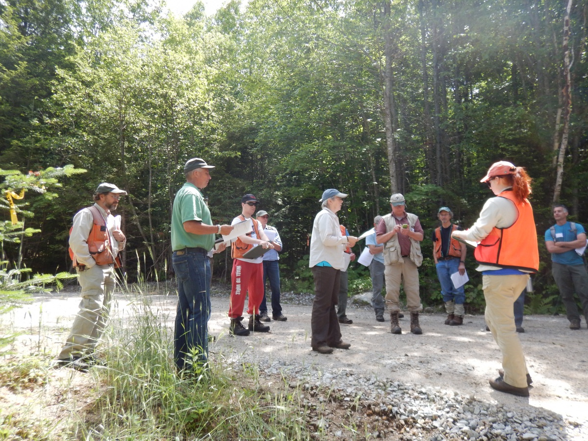 NRCS, USFS-WMNF, USFS State & Private Forestry, and UNH Cooperative Extension staff participated in an all-day field training using trainers from all four agencies’ staff. Each agency brought unique expertise and experience to the BMP monitoring project resulting in increased knowledge and skills about BMP techniques used to protect water quality and also a more uniform interpretation of BMP monitoring protocols.
Feedback and clarification as fieldwork progressed helped ensure quality and a minimal level of uniformity.
Finding the sites and receiving landowner permission
We used the N.H. Dept. of Environmental Services “One Stop” online listing to find minimum notification forestry permits on private lands in the project area. We identified 566 minimum notification permits filed within our time frame. We used the report-of-cut filings maintained by the N.H. Dept. of Revenue Administration to identify landowner contact information and were able to mail letters to 188 landowners describing our project and seeking permission to inspect their logging job. Of these 37 said “yes” in writing.
In all we visited:
- 36 private properties that had undergone a timber harvest within the last one to three years in the tax years 2011 to 2013 (4/1/2011 to 3/31/2014)
- Four state-owned properties with permission granted by the N.H. Division of Forests & Lands
- 8 NRCS EQIP practices that used BMPs
What we looked at—a focus on stream crossings—the greatest potential impact to water quality
In all, we looked at 24 log landings, 12 haul roads and 57 water crossings (44 of the crossings were on skid trails and 13 on haul roads) for a total of 93 sites where we evaluated BMP-effectiveness and looked for chemical spills. One harvest unit lacked a stream crossing and two units avoided crossings through planning for a total of 96 discrete locations for evaluation.
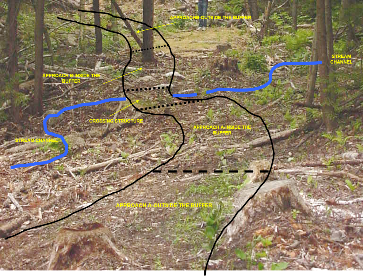
Stream crossings were evaluated by examining the crossing itself as well as the approaches to the crossing on both sides of the stream, both inside and outside a 50-foot buffer strip. We looked at five distinct areas for evidence of soil movement and sedimentation:
- Approach Area A (on the left bank as you look downstream)-Outside the 50-foot buffer
- Approach Area A-Inside the 50-foot buffer
- Crossing Structure
- Approach Area B-Outside the 50-foot buffer
- Approach Area B-Inside the 50-foot buffer
 More about the stream-crossings
Crossing types include:
- 36 poled fords
- 2 unimproved fords
- 1 culvert
- 9 bridges
- 7 unknown
We learned that crossings were on smaller streams:
- 30 Zero order (ephemeral)
- 17 First order
- 2 Second order
- 4 Third order
- 1 Fourth order
- 2 wetland
- 1 no stream crossing in area
- 3 stream crossings avoided by planning
Stream Description:
- 37 Intermittent
- 20 Perennial
Some information about the harvests
Harvest systems used:
- 62 in which wood was dragged (skidders, tracts, etc.)
- 17 in which wood is carried (forwarders, trailers, etc.)
- 11 unknown
- 6 EQIP practices
The person responsible for BMP implementation
- 46 forester
- 22 logger
- 28 unknown
What we learned—some thoughts from the county foresters
“I think the water bar is one of the most effective tools for diverting and slowing water flow preventing sedimentation.”
“I continue to be pleased at how quickly the land recovers and how small an impact a timber harvest is compared to other land uses.”
“Temporary bridges seemed to be the “premier” BMP in terms of preventing crossing-related delivery of sediment to streams. Of course, properly locating crossings and trails is a critical BMP as well.”
“We noticed in general that sites where a forester had been involved almost invariably had effective, appropriate use of BMPs. Where foresters had not been involved, things were a little less predictable, but by and large BMP use was adequate across the board.”
 What we learned—the bottom-line
We found that BMPs resulted in stable soil at 82 percent of the stream crossings. When soil moved into the water body, 7 percent of the time it was a trace amount of sediment and 11 percent of the time it was measureable. We found that 100 percent of the time, the reason for sediment delivery was inappropriate design or location of the crossing. Other factors such as timing of the harvest, inadequate installation and maintenance, or other human or natural disturbance events didn’t cause the sedimentation.
87 percent of the time soil was stable in the approaches outside the 50-foot buffer and stable 74 percent of the time within the 50-foot buffers.
We also assessed buffers, water crossings and landings for evidence of chemical spills (e.g. lubricant, fuel, hydraulic fluid or anti-freeze) and found none in our 93 sample-locations.
On the 24 log landings, 88 percent showed no evidence of erosion and 8 percent showed erosion, but no evidence of sediment reaching the water. Only one landing showed evidence of sediment reaching the water and that was because of inappropriate location or design.
Seven of the 12 (58%) haul roads showed no evidence of erosion into the surrounding landscape; 5 (42%) showed evidence of erosion, but no evidence that sediment reached a water body.
In answer to our question, “When BMPs are used, do they effectively protect water quality….?
The results of this study indicates that BMPs are an effective tool to prevent erosion and sedimentation thereby protecting water quality. In the spirit of continuous improvement, this study suggests:
- Though BMPs are well-accepted and on virtually every logging job, it is reasonable to expect that increasing the use of BMPs during timber harvesting will increase the protection of New Hampshire’s water.
- Improving the design and location of crossings will lessen the amount of sediment reaching water.
Download this resource for the complete report and printable version.
Project management: Karen Bennett
Fieldwork completed by:
Tim Fleury
Jim Frohn
Andrew Fast
Dode Gladders
Brendan Prusik
Wendy Scribner
Sarah Smith
Data management and analysis by: Alicia Carlson
Illustration credits:
Culverts, sediment and buffers from Dave Welsch, U.S. Forest Service, retired
Stream order illustration by Kristina Ferrare from Bennett, Karen P. editor. 2010. Good Forestry in the Granite State: Recommended Voluntary Forest Management Practices for New Hampshire (second edition). University of New Hampshire Cooperative Extension, Durham, N.H. 224 p.
All others from UNH Cooperative Extension
Author(s)
