Introduction to Forestry Laws
New Hampshire has laws and regulations designed to encourage responsible timber harvesting and minimize environmental impacts of logging. Landowners, loggers, and foresters have the responsibility to know and understand New Hampshire’s timber harvesting laws. In addition, municipal officials have the authority and responsibility to work with state agencies to ensure that these laws are consistently enforced.
This publication is intended to assist municipal officials, landowners, and natural resource professionals working in New Hampshire’s forests.
This guide presents the following information:
- Why and how town officials are to be notified of timber harvesting
- State laws regarding timber tax assessment
- State laws that protect wetlands and water resources during timber harvesting
- State laws that regulate timber harvesting operations
- Local official’s role in enforcing state laws
- State agencies responsible for enforcing these laws and who to contact for enforcement assistance.
New Hampshire forest landowners have several options available to help them with forest management. UNH Cooperative Extension forest resource educators (also known as County Foresters), located in each county, are available to provide objective guidance toward accomplishing forest management goals (see the section below How to Contact State Agencies and Organizations ). To assist in developing forest management plans and/or to implement a timber harvest, landowners are strongly encouraged to use the services of licensed foresters. A list of licensed foresters is available through the UNH Cooperative Extension’s Forestry Information Center at (800) 444-8978 or can be found on UNH Cooperative Extension’s website.
New Hampshire state laws, developed over the last several decades, address concerns related to timber harvesting. The effectiveness of these laws depends a great deal on the awareness of landowners and loggers, and the commitment of state and local officials to bring problems to the attention of enforcing agencies. The services of state forest rangers, the state timber tax appraiser, UNH Cooperative Extension educators in forest resources, licensed foresters, and professional timber harvesters are available to help evaluate potential timber harvesting problems. See the section How to Contact State Agencies and Organizations below for listings of those agencies offering assistance.
New Hampshire state laws, developed over the last several decades, address concerns related to timber harvesting. The effectiveness of these laws depends a great deal on the awareness of landowners and loggers, and the commitment of state and local officials to bring problems to the attention of enforcing agencies. The services of state forest rangers, the state timber tax appraiser, UNH Cooperative Extension educators in forest resources, licensed foresters, and professional timber harvesters are available to help evaluate potential timber harvesting problems. See pages 30 and 31 for listings of those agencies offering assistance.
One of New Hampshire’s most attractive features is its rural landscape, which serves as the foundation for the state’s $1.7 billion forest products industry. New Hampshire’s working forest also provides a spectacular backdrop that attracts tourists—our state’s number one industry.
Of New Hampshire’s approximately 5.75 million acres of land area, 82% (4.7 million acres) is forested. Of this forested acreage, 94% (4.4 million acres) is classified as timberland. Timberland is defined as land that is producing or capable of producing crops of wood.
New Hampshire’s forests are mostly in private ownership. Of the total area of timberland in New Hampshire, over 72% is privately owned. This leaves approximately 24% of New Hampshire forest in public ownership: either federal, state or municipal.
New Hampshire Forest Facts
- Forests cover 82% of the state’s landscape
- 72.61% of New Hampshire’s timberlands are privately owned
- Yearly, the forest products industry contributes $1.8 billion to the state’s economy
- $1.12 billion of tourist spending each year is attributable to open space
- New Hampshire has an estimated 4.7 million acres of forest land.
Growing concern about timber harvesting, whether for forest management or for land development, has led, in some situations, to the development of local ordinances. Sensing that increased local regulation could indeed threaten the “working forest,” in 1989 the New Hampshire state legislature formally recognized the importance of forestry to the state through amendments to the local planning and zoning, enabling legislation. RSA 672:1, III c, now reads:
IIIc. Forestry, when practiced in accordance with accepted silvicultural principles, constitutes a beneficial and desirable use of New Hampshire’s forest resource. Forestry contributes greatly to the economy of the state through a vital forest products industry, and to the health of the state’s forest and wildlife resources through sustained forest productivity, and through improvement of wildlife habitats. New Hampshire’s forests are an essential component of the landscape and add immeasurably to the quality of life for the state’s citizens. Because New Hampshire is a heavily forested state, forestry activities, including the harvest and transport of forest products, are often carried out near populated areas.
Further, the harvesting of timber often represents the only income that can be derived from property without resorting to development of the property for more intense uses, and pursuant to RSA 79-A:1, the state of New Hampshire has declared that it is in the public interest to encourage the preservation of open space by conserving forest and other natural resources. Therefore, forestry activities, including the harvest and transport of forest products, shall not be unreasonably limited by use of municipal planning and zoning powers or by the unreasonable interpretation of such powers.
Privately-owned, undeveloped land stands a better chance of remaining undeveloped if landowners receive income through the production of crops, livestock, or forest products. Towns also receive important revenue from timber harvests, as 10 percent of the stumpage value of the trees harvested is paid to the town in the form of the yield tax. Furthermore, assuring the economic viability of timber land and tailoring regulations to promote rather than conserving open space hinder this goal may be the best means of conserving open space in New Hampshire.
The University of New Hampshire Cooperative Extension and Society for the Protection of NH Forests completed economic studies of several communities demonstrating the economic value of open-spaced land. The cost of community services process was used to compare residential, commercial, industrial and open-space land use categories in each community. Cost of community services studies demonstrate that open space is an economic asset contributing to the stability of community tax rates. While there are many people who challenge the value of open space as a contributor to gross revenues and property taxes, research indicates otherwise. Clearly, each community should assess its own fiscal situation from both sides of the balance sheet, both revenue and costs.
The following information is excerpted from “A Layperson’s Guide to NH Current Use.” *Some statistical data has been updated.
In 2023, New Hampshire’s landmark current use law, RSA 79-A, will celebrate 50 years as one of the nation’s simplest and most effective open space taxation programs. As the state becomes more dependent on the property tax to fund municipal services, the importance of the current use increases. As of 2019, Approximately 3 million acres (52% of New Hampshire’s total acreage) /is enrolled in the current use program by some 42,000 landowners.
What is Current Use?
Current use is a property taxing strategy designed to encourage landowners to keep their open space undeveloped. Rather than a property being taxed at its real estate market value, the land is taxed on its income producing capability. For example, through current use, land may be taxed as a woodlot or a farm, not as a potential site for houses.
Undeveloped farmland, forestland, and certified Tree Farms, may all enroll in current use. The law also covers land such as wetlands and other sites unsuitable for agriculture or forest products. Land in current use can be posted against trespassing, but owners receive additional tax savings if they keep their land open and without fee all year for hunting, fishing, snowshoeing, hiking, skiing, and nature observation. The Current Use Board also recognizes that there are extra costs associated with good forest management. Owners who meet criteria for forestland, with documented stewardship, may receive lower assessments.
Typically, land holdings must contain at least 10 acres of unimproved open space land. Buildings and other improvements, such as lawns, driveways and septic systems are excluded from current use.
Land is not automatically enrolled in current use. Landowners must apply to their town, committing their land to open space conservation. The selectman, town forester, or other assessing official appraises the land using criteria established by the state Current Use Board. Like other types of real estate, this valuation is equalized annually for the purpose of assessing taxes.
When land is developed, or an owner otherwise changes its use to one not qualifying for current use, a land use change tax is charged. The rate is 10% of the “full and true value” of the land and is usually assessed at the time the physical change has begun. A study by D. E. Morris at UNH, Town Incomes from the Land Use Change Tax 1980-1987, shows that when land comes out of current use, towns receive more than the tax revenue they would have received had they simply taxed the land at a higher rate all along, rather than allowing the land to be in current use.
For more information about Current Use, please refer to the following resources:
This is only a synopsis of the law, further clarification and reference to the applicable laws and rules may be found on the NH Department of Revenue Administration website.
Notice of Intent to Cut Wood or Timber (RSA 79:10)
The State of New Hampshire has a real estate tax and by definition timber is considered to be real estate, and therefore taxable. However, the method in which it is taxed is different from other real estate and is describe in the State Constitution. Timber is taxed only at the time it is cut and at a rate which encourages the growing of timber. In order for the municipal assessing officials to be aware of cutting operations they must be notified of the cutting by the owner filing a Notice of Intent to Cut Wood or Timber (PA-7) form, commonly referred to as simply the Intent to Cut. The Intent to Cut form (Appendix A), which is required by law, notifies the assessing officials, NH Department of Revenue Administration (DRA) and the NH Division of Forests and Lands.
Timber on all land ownership is taxable at 10% of the stumpage value at the time of cutting. The only exemptions are as follows:
Items 1-6: As of July 1, 2024, no Intent to Cut required and timber not taxable by the owner.
- 15 MBF* saw logs and 30 cords fuel wood for personal use by the owner. (RSA 79:1 II(b) 1 &2) (Rev. 3407.01 (a) 1 & 2)
- 15 MBF saw logs and 30 cords of wood and 300 tons of whole tree chips for land conversion purposes when all permits for the conversion have been received. (RSA 79:1 II (b) 5) If these volumes are exceeded for the land conversion project, then none of the timber is exempt. (Rev.3407.01(a) (4) &(b))
- Shade and ornamental trees, usually considered to be trees within striking distance of a building. (RSA 79:2)
- Christmas trees, fruit trees, and nursery stock and short rotation tree fiber. (RSA 79:2)
- Any amount of firewood for maple syrup production. (RSA 79:1 II (b) 2)
- Government and utilities not selling the wood. (RSA 79:1 II (b) 3 & 4)
*MBF stands for one thousand board feet
The Notice of Intent to Cut Wood or Timber (PA-7), must be completed with a volume estimate, signed by the assessing officials and posted on the job site before any cutting requiring a form PA-7 can start.
A Supplemental Intent to Cut form shall not be required when the total volume of the cut does not exceed the total volume on the original Intent to Cut by 25%, except if a timber tax bond was required with the original Notice of Intent to Cut. If a bond was required with the original Intent to Cut, an additional bond will be required and supplemental Intent to Cut (Form PA-7) filed and signed before the original volumes are exceeded.
Town officials have 15 days to sign the Notice of Intent to Cut form (RSA 79:10 1(b)). They may withhold signing only for the following reasons:
- The form has been improperly filled out (RSA 79:10);
- Land is enrolled in the unproductive current use category that does not allow timber harvesting. (RSA 79-A:2,XIII), Current Use Administrative Rule Cub 306.02 (c);
- A timber tax bond is required but has not been posted (RSA 79:3-a);
- All owners of record listed on the property record card have not signed the Notice of Intent to Cut Wood or Timber form PA-7 (RSA 79:1. II & RSA 79:10 I.(a))
If the municipal officials have not acted on the Intent to Cut within 15 days of receipt and the landowner has met all conditions for approval, and the assessing officials have not communicated to the landowner a reason why conditions of approval have not been met, the landowner may start the cutting operation after submitting a copy of the intent and providing the date of filing to the commissioner of revenue administration. If the assessing officials thereafter determine that the conditions for approval have not been met, the assessing officials shall notify the owner and the person responsible for the cutting explaining why the submitted intent does not meet the conditions for signature. Upon delivery of such notice, the cutting operation shall cease until such conditions are met and the intent is signed. (RSA79:10-2. (b) & (c) and Rev3402.03(b)(3) & (4))
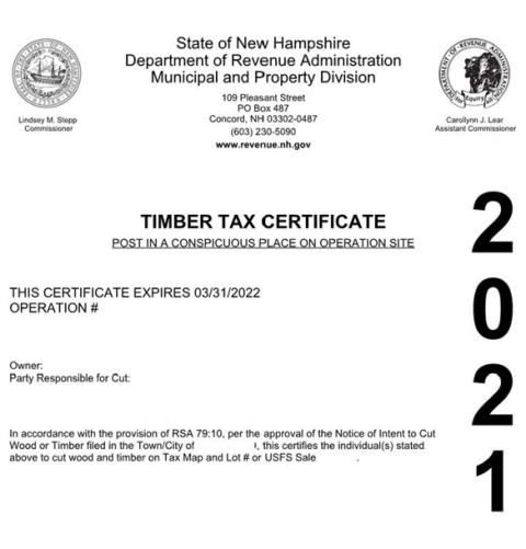
A timber cutting operation may not start until one of the following are posted in a conspicuous place within the area of cutting:
- The Timber Tax Certificate from the DRA (See Sample Below).
- A copy of the Notice of Intent to Cut (PA-7) signed by the assessing officials; or
- A copy of the Notice of Intent to Cut (PA-7) with the operation number along with the date, time, and name of municipal official or employee who provided the operation number.
- A copy of the Notice of Intent to Cut (PA-7) along with the date of filing to the commissioner of revenue administration indicated.
Tax Responsibility: (RSA 79:1 II(a))
The responsibility for the timber tax depends on the type of ownership and must be one of the following:
- Owner with timber rights on their own land (joint tenants).
- Owner with timber rights on their own land (tenants in common).
- Persons with deeded timber rights on land they previously owned.
- Persons purchasing timber on public lands (federal, state, county, town, etc.).
Timber Tax Bond: (RSA 79:10-a)
Owners that own land within the town the cutting is to take place and are current on property taxes and timber taxes cannot be required to post a timber tax bond. All other owners must post a timber tax bond before the Notice of Intent to Cut is signed. Timber tax bonds are usually equal to the estimated timber tax.
Extensions: (RSA 79:10, II.) (RSA 79:11, II.)
Extensions are allowed upon written request by the owner to the assessing officials prior to April 1.
Extensions allow cutting to continue through June 30 and reports are due August 15.
Report of Wood Cut: (RSA 79:11)
Report of Wood Cut forms are sent to the owners filing a notice along with a certificate which SHALL be posted at the job site. Reports of wood cut must be filed with the town within 60 days of completion or by May 15, whichever comes first. Extensions are allowed upon written request by the owner to the assessing officials prior to April 1. The report form serves as the basis for determining the timber yield tax.
Appeal Process: (RSA 79:8)
If a taxpayer believes he or she has been overtaxed, the taxpayer must appeal to the town within 90 days of the tax bill. If the town denies the appeal, then the taxpayer may appeal to the Board of Tax and Land Appeals within 6 months of the tax bill for an appeal board hearing. Resources for determining stumpage values are available on the NH DRA website to assist owners and towns in proper assessment of timber per NH timber tax law.
Penalties, Doomage and Enforcement: (RSA 79:12) (RSA 21:J 39) (RSA 79:28 & 28-a)
Fines for non-compliance range up to $2000. A Doomage penalty may be assessed for improper reporting. (Doomage is two times what the tax would have been if the report had been timely filed and truly reported.) The DRA and NH Division of Forests and Lands have authority to issue a cease-and-desist order for any cutting operation in violation of RSA 79.
In accordance with RSA 79 New Hampshire Timber Tax (See RSA 79:1 III “Stumpage Value”)
The following is a guide to assist municipalities in assessing stumpage value (the value of standing timber or timber “on the stump”) and to assist owners in providing supporting evidence to municipalities when proving the reasonableness of a claim of excessive stumpage value assessment. The burden of proof is upon the owner to demonstrate the reasonableness of a claim. The assessing officials are charged to assess the full and true stumpage value at the time of cutting in the same manner as other property values pursuant to RSA 75:1.
When assessing the value of wood and timber, the following factors should be considered:
- Value is based on the most probable price that would be paid, not the average, highest or lowest price.
- Value recognizes the highest and best use of the wood and timber.
- Value is expressed in terms of money.
- Value recognizes that the timber was exposed to the open market for a reasonable time.
- Value recognizes that both buyer and seller are informed of the uses to which the wood and timber may be used.
- Value assumes an arm’s length transaction in the open market. In other words, there is no special relationship or collusion between the buyer and seller.
- Value assumes a willing buyer and willing seller, with no advantage being taken by either party.
The assessing officials shall take into consideration the quality and location of the timber, the size of the sale, and any other factors necessary to harvest the wood or timber that affect the value of timber being cut. Assessing officials shall consider stumpage prices, allowing for costs incurred by the owner to improve access, i.e., road costs. Only costs which are necessary and reasonable to access and remove stumpage can be considered
Furthermore, some costs such as road improvement, should be prorated over the entire volume of wood favored by the cost. If only a portion of the wood is being cut, which was accessed by the construction of a road, then only that portion of the cost of the road c
an be charged against the cutting operation during that year. Costs created by constraints within a timber sale contract which limit operating beyond federal, state and local requirements and which are not necessary, i.e., specific logging equipment, aesthetic concerns, cannot be charged against the operation.
The assessing officials shall consider the stumpage price paid for standing timber when reviewing a claim of over-assessment. If the assessing officials disagree that the price paid is an accurate indication of assessed value, then they must inspect the property and assess in accordance with RSA 79:1.
The following evidence may be submitted by the owner to support a claim for abatement to the assessing officials:
- Competitive bid results
- Timber sale contract
- Costs incurred to access and remove timber
- Timber inventory of wood lot (for proration of road costs)
- Map showing road locations
- Comparative, competitive bid results during the same time of the cutting operation being assessed indicating prices paid for similar wood or timber.
- Payment received for harvested timber at purchasing mill, deducting expenses to truck, yard, and cut.
- Road and landing construction costs incurred to access and remove the timber.
- Timber sale contracts not a result of competitive bid may be a poor indication of full and true value. Incidental services received by the owner, rather than stumpage payment, must be considered.
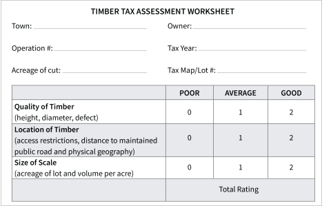
| Rating | Percentage within Range |
|---|---|
| 0 | 0% |
| 1 | 17% |
| 2 | 33% |
| 3 | 50% |
| 4 | 66% |
| 5 | 83% |
| 6 | 100% |
Example: If the white pine stumpage DRA range is $80-$180/MBF ** and the quality, location and size of sale are average, poor and large respectively. The calculated scale would be 1 for quality, 0 for location and 2 for size of sale, for a total of 3 out of a maximum possible of 6 or 50%.
50% of the difference ($100) between $80 and $180 is $50 which, when added to the base of $80 arrives at an assessment of $130 per MBF for white pine stumpage with these specific attributes. (Refer to the Timber Tax Assessment Worksheet Appendix B)
**For current stumpage ranges check the DRA website
Note: Actual numbers are needed, reasons such as “taxes are too high” are not sufficient reasons for abatement. Professional fees, i.e., forester’s fees or commissions, timber marking, sale layout and supervision, are considered to be an option of the owner and not necessary costs to be considered.
The following is one practical approach towns may use to assess timber. This matrix above attempts to satisfy the need to obtain factual information regarding the location of the timber, quality of the timber, and the size of the cutting operation.
The NH Department of Revenue Administration will assist municipalities in proper assessing procedure for timber and in reviewing documentation submitted to demonstrate the reasonableness of a claim of timber value by an owner. Owners may engage the services of a licensed forester or other professional to present a claim.
Timeline for Timber Tax Reporting
(For Municipal Use) - Tax Year April 1 through March 31
March 31: Last day an owner may request a Notice of Intent to Cut extension. (In writing to the selectman by the owner.)
May 15: Reports due (without report extension).
June 1: Reports due (No further extensions can be granted).
June 2: Notify DRA timber tax appraiser of late Reports. (Estimate of cut volume to be made for doomage penalty purposes.)
June 30: A timber harvest granted an extension must be completed.
August 15: Extended operation report due.
A forest management plan that includes timber harvesting should incorporate regulatory requirements into the planning process. Many timber harvesting operations encounter wetlands or surface water during logging and must implement measures to eliminate or reduce impact and obtain appropriate permits. The purpose of this section is to explain what areas are regulated by the New Hampshire Department of Environmental Services (DES) and how you can identify them.
What is the New Hampshire Wetlands Law?
Wetlands and surface water are regulated under RSA 482-A, which was enacted in 1969. The law states “no person shall excavate, remove, fill, dredge, or construct a structure in surface water, bank, or a wetland without a permit from the NH Department of Environmental Services.”
The purpose of the law is to protect tidal and fresh waters and wetlands from unregulated alteration. Why the protection? The legislature recognizes that these areas are valuable to the State of New Hampshire based on the functions they provide. Wetland functions include nutrients and pollutant filtering, storm water retention, and wildlife habitat.
The permitting process allows DES to evaluate projects and their impacts on a wetland’s functions. In 1989, the law was modified to allow the timber industry to use a notification process for minimum impact projects instead of using the standard application process. The notification known today as the Forestry Statutory Permit-By-Notification (SPN) offers an opportunity for DES to monitor projects but allows harvesting to begin with minimal delay provided that proper crossings are installed, the crossing is the alternative with the least impact to the wetlands, and best management practices* (BMPs) are used.
New Hampshire Best Management Practices for Erosion Control on Timber Harvesting Operations 2016, published by the University of New Hampshire Cooperative Extension (Env-Wt 102.19).
What Areas Are Regulated?
DES regulates dredge and fill activity in freshwater and tidal wetlands. DES defines a wetland as an area that is inundated or saturated by surface water or groundwater at a frequency and duration sufficient to support, and that under normal conditions does support, a prevalence of vegetation typically adapted for life in saturated soil conditions. In other words, it is an area where you find specific plants that can grow in wet soil conditions.
Dredge and fill activities in surface water are also regulated. These areas include tidal waters, lakes, ponds, rivers, brooks, vernal pools, and seasonal or “intermittent” streams. Intermittent is defined as a stream which does not flow year-round, but flows long enough to form a defined channel or have wetland vegetation established. Activities in intermittent streams and vernal pools are regulated during all times of the year, even when they are dry.
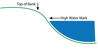
The bank adjacent to surface waters is another jurisdictional area in which dredge and fill activities are regulated. A break in slope marks the top of the bank, which is the upper limit of jurisdiction. DES also has jurisdiction in the tidal buffer zone. The buffer zone is land (including upland areas) within 100 feet from the highest observable tide line. The jurisdictional areas most commonly encountered in the timber harvesting industry are surface water (perennial and intermittent streams) and forested wetlands.
Prime Wetlands
Prime Wetlands are designated by a municipality (and not state mandated) according to the requirements of RSA 482-A: 15 and Chapter Env-Wt 700 of the DES administrative rules. As of February 2022, 33 municipalities have bestowed the title of “Prime” unto their unique or larger wetlands.
Per RSA 482-A:11 IV, The DES shall not grant a permit with respect to any project to be undertaken in a prime wetland (RSA 482-A:15) or within 100 feet of any prime wetland where a 100 foot buffer was required at the time of designation, unless the DES first notifies the local governing body, the planning board, if any, and the conservation commission, if any, in the municipality within which the wetlands lie, either in whole or in part, of its decision. Any such permit shall not be issued unless the DES finds clear and convincing evidence on the basis of all information considered, and after a public hearing, if deemed necessary under RSA 482-A:8, that the proposed project, either alone or in conjunction with other human activity, will not result in the significant net loss of any of the values set forth in RSA 482-A:1.
For forestry activities that will occur in a designated prime wetlands or prime wetland buffer, a waiver (Env-Wt706) needs to be filed with DES in conjunction with the Forestry Statutory Permit-By-Notification (SPN) (RSA 482-A:3, V), or other applicable dredge and fill permit if the project is beyond the scope of the SPN permit. The waiver will need to include the appropriate filing fees and address all the requirements under Env-Wt 706.02 to be considered for approval by the DES and the Local Municipality.
Unlike in other areas where you can begin work once you have submitted a complete permit; you can’t start work in a prime wetland until you receive the Tyvek indicating full approval of the permit and waiver.
Past legislation eliminated all wetlands buffers except for those adopted between September 2009 and August 2012. While there are 33 towns with prime wetlands, there are only 7 towns* with the 100-foot wetland buffer. The cities and towns listed in the following table have prime wetlands as of February 2022, check with NHDES and local municipalities for updates.
Towns with Prime Wetlands
| Andover | Hooksett |
| Atkinson* | Meredith |
| Barrington | Nashua |
| Bow* | New Ipswich |
| Brentwood* | New London |
| Brookline | Newington |
| Center Harbor* | Newmarket |
| Derry | Northwood |
| Enfield | Pelham |
| Exeter | Portsmouth* |
| Fremont | Salem |
| Gilford | Sanbornton |
| Goffstown | Sandwich |
| Hampton* | Tamworth |
| Hampton Falls* | Weare |
| Hillsborough* | Wolfeboro |
| Holderness | *100-Foot Buffers |
What Is a Forested Wetland? How Can I Recognize One?
Wetland areas dominated by trees or shrubs are called swamps. A typical swamp vegetative community may consist of a tree layer, a sapling layer, a shrub or bush layer, an herbaceous layer (wildflowers, ferns, grasses, sedge, etc.), and a bryophyte layer (mosses). Knowing which trees can grow in wetlands is the first step in identifying a forested wetland. See Appendix A of New Hampshire Best Management Practices for Erosion Control on Timber Harvesting Operations for a frequency occurrence list of wetland trees and shrubs in New Hampshire.
What Are Some Other Indicators for Wetlands?
- Water at or close to the surface throughout the year.
- A wetland may become drier in July and August, but it will usually pond water for several days after a heavy rain. Look for evidence of dark stained or wet leaf litter. The type of soil will also provide information relative to a high-water table. A quick soil test pit may show dark or gray wetland (hydric) soil instead of bright, light colors common to upland soils (tan, yellow, brown). For most soil types in central New Hampshire, this is best remembered by the adage “Red and yellow, happy fellow, dark and gray, stay away.”
- The vegetative community in the area.
- Thick growth of sphagnum moss and various species of ferns are a clue that you might be in a wetland. Trees with shallow, exposed root systems, trees with buttressed trunks, or in some cases, trees with multiple trunks at the same base may indicate a saturated soil condition. The high-water table limits the trees’ ability to carry out the carbon dioxide/oxygen exchange, therefore root systems grow near or above the soil surface.
- Thick deposits of organic matter on the ground.
- The ground may bounce slightly underfoot. The lack of oxygen in saturated soil will slow down the decomposition of leaf and woody material, which allows it to accumulate.
- The terrain or difference in elevation/topography.
- Wetlands are generally located at the base of slopes and in flatter areas. There may be a wetland associated with and adjacent to surface waters such as streams, rivers, lakes, and ponds. Groundwater may break out at the base of a small hill and develop into a seep. Areas that are frequently flooded may have a highwater line stain on rocks and tree trunks.
- A pit and mound wetland is an area where vegetation grows on the mounds (usually old decayed trunks from fallen trees) and water collects in the pits (usually depressions left from when a tree became uprooted). These wetlands may be unusual because upland trees, such as pine, which normally never grow in wetlands, can grow on a mound and the site is still considered wetland.
Vernal Pools
Vernal pools are surface waters or wetlands which provide breeding habitat for amphibians and invertebrates that have adapted to unique environments (Env-Wt. 101.99). They usually occur in shallow basins, have no permanent flowing outlet, hold water for at least two months after spring ice out, lack a viable fish population and support certain organisms. Vernal pools are usually dry in the late summer months. While DES currently does not require setbacks from vernal pools, DES does encourage that foresters and loggers avoid harvesting near them. Good Forestry in the Granite State is a resource for voluntary recommended BMPs for establishing riparian management zones around vernal pools during timber harvests: Vernal Pools and the Surrounding Forest.
What Common Forestry Activities Are Regulated?
RSA 482-A is commonly referred to as the dredge and fill law, since these are the regulated activities. Dredge is defined as the excavation or otherwise disturbance of the soil in a wetland, bank or surface waterbody. Some examples of dredge would be:
- Excavating a bank to install a bridge abutment.
- Digging in a stream or wetland to install a culvert
- Machinery ruts in a wetland, bank, or waterbody
- Stumping or removing rocks in a wetland or bank
Fill is defined as material that has been deposited or caused to be deposited by human activity. Some examples of fill:
- Material, such as gravel, placed in a wetland or stream for a skid trail or truck road.
- Tree limbs (corduroy) placed in wetlands or drainage swale for a skid trail.
- Logs or rock (pole/stone ford) placed in stream bed for a skid trail.
- Logs or rock placed in stream bank for a bridge abutment.
- Stockpiling of tree butts, slash, and debris in a wetland, bank, or waterbody.
Using the Forestry Statutory Permit-By-Notification (SPN)
If your proposed forestry project involves any of the above activities by crossing surface waters or non-frozen wetlands, then you are required to file a Forestry Statutory Permit-By-Notification (SPN) (RSA 482-A:3, V) with the NH Department of Environmental Services. If you can agree to the statements on the form (indicated with either the landowner/applicant or forester or logger’s initials) you can use the form (See Appendix D for Forestry Statutory for Permit-by-Notification. A copy of a Natural Heritage Bureau (NHB) Datacheck Receipt confirming review of the proposed project must also be included.
Following submission of SPN, monitor your notification status on OneStop. If the department determines that a notification is administratively complete and the project as described meets the requirements for a SPN, within five working days of receipt of the notification, the department will change the status on OneStop to “complete” (Env-Wt 308.05C9)). Notifications issued by the department are valid for two years (RSA 482-A:3, V. (a)).
If you proceed with the work covered by the notification without first filing a complete and correct SPN form or obtaining a difference type of authorization, then:
- All Work done shall be deemed to have been done without a permit or exemption.
- The person shale file an application for an after-the-fact standard permit (Env-Wt 3098.05 (f)).
Prior to commencing the work covered by the SPN, the person responsible for a project must post at the site a copy of the SPN posted by the department on its website or provided by the department pursuant to Env-Wt 308.05 (d)(2) (Env-Wt 308.07(a)).
The certificate (PA-7) issued under RSA 79:10 shall also be posted upon receipt. Prior to receipt of such certificate, a copy of the intent to cut form, signed by the appropriate municipal official, shall be available on the job site, and shall be shown to any person who asks to see it (RSA 482-A:3, V(e)). (See appendix F for a sample Confirmation of Complete SPN)
If the scope of work will exceed the criteria outlined on the notification (SPN), you will be required to file a different wetlands impact permit application. If you question whether your project would meet the dredge and fill definition or need information on the permitting process, please contact the DES Wetlands Bureau at (603) 271-2147, which is located at 29 Hazen Drive, PO Box 95, Concord, NH 03302 or visit the website.
To use a Forestry Statutory Permit-By-Notification (SPN) (RSA 482-A:3, V), the following minimum criteria must be met:
- Cannot exceed 3000 square feet of permanent wetlands impacts per crossing (except for corduroy) (Env-Wt 520.05(b)(2)). A corduroy skid trail for any single forested wetland crossing does not exceed 1,000 feet in length, measured along the proposed skid trail.
- Cannot propose impacts to a bog, marsh, sand dune, tidal wetland, or undisturbed tidal buffer zone (Env-Wt 520.05(c)(2)).
- Cannot propose impacts in an area with documented occurrences of a protected species or habitat where the responsible party has not received recommendations from the Department of Natural and Cultural Resources’ Natural Heritage Bureau (NHB) or NH Fish and Game Dept (NHF&G), or both, as applicable, regarding the impacted protected species or habitat (Env-Wt 407.o2(c); 520.05(c)(3)).
In addition to the above criteria, forestry activities must meet all other requirements as outlined in the details of the proposed activities listed below and indicated on the Forestry Statutory Permit-By-Notification (SPN) (RSA 482-A:3, V)
- Roadway construction through forested wetlands for the purpose of conducting forest management activities where:
- Roads are cleared only by felling timber in the roadway
- The road base is constructed using no fill other than: 1. Snow pushed onto and frozen over the road base, or
- Stumps inverted in places where support of the road base is necessary
- The minimum length and number of ditches necessary to create and maintain adequate drainage are constructed in accordance with the New Hampshire Best Management Practices for Erosion Control on Timber Harvesting Operations (Forestry BMPs) and water quality protection measures
- Each road crossing is no more than 15 feet wide
- Stream crossings incorporate pole fords with no removal of stumps within the stream banks
- Spring retirement of winter roads includes soil stabilization and drainage, such as water bars, necessary to prevent the roadway from redirecting or channeling surface water runoff; and
- A corduroy skid trail for any single forested wetland crossing does not exceed 1,000 feet in length, measured along the proposed skid trail
- Installation of a permanent crossing, such as a culvert, stone ford, and associated fill, to permit vehicular access to a parcel for forest management, only if:
- Access is not used for subdivision, development, or other land conversion to non-forestry uses, except that forestry uses may be combined with normal agricultural operations or trail construction or maintenance, or both
- Roadway width exclusive of side slopes, at the crossing does not exceed 20 feet
- Roadway width, measured at the toe of the roadway side slopes is minimized and does not exceed 50 feet
- Fill for any single wetland crossing does not exceed 50 feet in length, measured along the proposed access way
- Wetland crossings are limited to those that:
- Do not impact any bogs, vernal pools, marshes, sand dunes, tidal wetlands, undisturbed tidal buffer zone
- Are not located in designated prime wetlands or duly-established 100-foot buffers unless a prime wetlands waiver has been obtained in accordance with Env-Wt 700
- Only cross a swamp or wet meadow if such swamp or wet meadow has no standing water for 10 months per year or more and
- Are not located in a protected species habitat unless authorized under Env-Wt 407 and
- For stream crossings, the scoured stream width is no wider than 8 feet.
- Construction of a temporary crossing on a non-tidal watercourse of any width for the transportation of forest products, only if the temporary crossing:
- Is not in or adjacent to designated prime wetlands or a duly-established 100-foot buffer unless a prime wetlands waiver has been obtained in accordance with Env-Wt 700;
- Is not located in a protected species habitat unless authorized under Env-Wt 407;
- Is not used for access to property that has been converted to non-forestry uses, except that forestry uses may be combined with normal agricultural operations or trail construction or maintenance or both;
- Incorporates not more than one pier or post per 15 feet of span;
- Incorporates one or more abutments in the stream bank(s) if necessary; and
- If other than corduroy, is removed within 2 years of the date the SPN is issued by the NHDES Wetlands Bureau, provided that if weather conditions preclude the removal of the crossing when the work is completed, the crossing may remain in place until weather conditions allow its removal.
- Repair of existing forestry road crossing that:
- Crosses a watercourse for which the scoured channel is 8 feet wide or narrower;
- Is not in designated prime wetlands or a duly-established 100-foot buffer unless a prime wetlands waiver has been obtained in accordance with Env-Wt 700;
- Is not located in a protected species habitat unless authorized under Env-Wt 407.
- Is not used for access to property that has been converted to non-forestry uses, except that forestry uses may be combined with normal agricultural operations or trail construction or maintenance or both.
- The Structure disturbs less than 3000 square feet.
Closeout Requirement for SPN
Within 10 calendar days following completion of the work covered by the SPN, the person responsible for the project shall submit to The Department of Environmental Services, confirmation of completion of the project, either by paper copy or electronically (Env-Wt 308.07(b)).

Can You Cross a Stream or River Without a Permit?
Yes, if you go from “top of bank to top of bank” you don’t need to file a permit even for a permanent bridge of any size, as long as no work is done in, or fill placed in, the jurisdictional area. The new stream crossing rules are designed to encourage you to span streams—for public safety and to prevent the blockage of aquatic organisms.
Natural Heritage Bureau DataCheck Tool: Avoiding Harvesting Impacts to Protected Species
The NH Natural Heritage Bureau (NHB) finds, tracks, and facilitates the protection of New Hampshire’s rare plants, and exemplary natural communities (types of forests, wetlands, grasslands, etc.). As a bureau within the Division of Forests & Lands, the Natural Heritage Bureau is fundamentally a service to New Hampshire landowners and land managers. The Natural Heritage Bureau is not a regulatory agency; instead, they work with landowners and land managers to help them protect the State’s natural heritage while meeting their land-use needs. The NH Natural Heritage Bureau also maintains information on rare wildlife in cooperation with the NH Fish & Game Department’s Nongame & Endangered Wildlife Program, which has legal jurisdiction over New Hampshire wildlife.
In order to meet the criteria requirements for the Forestry Statutory Permit-By-Notification (SPN), a Natural Heritage Bureau data check is required.
The DataCheck Tool website, developed jointly with the NH Department of Environmental Services and the NH Fish & Game Department can be used to check for rare species to satisfy a permit or regulatory requirement.
Skid Trails, Truck Roads, and Landings
Properties in New Hampshire managed strictly for forestry, usually use the same landing areas, skid trails, and truck roads. A truck road is the main travel way from the town road to the landing. A landing is a place where trees and logs are gathered in or near a harvest site for further processing and transport. A skid trail is an unsurfaced, temporary single-lane trail used to skid wood. The following guidelines summarize the criteria for permit requirements for skid trails, truck roads, and landings during logging operations (Env-Wt 300, Env-Wt 304.05):
- Impacts to surface waters and wetlands shall be avoided or minimized in accordance with Env-Wt 302.04(b) and (c) (Env-Wt 304.05 (a)).
- All skid trails, truck roads, and log landings shall be located far enough from surface waters and wetlands so that waterborne soil particles will settle out before reaching the surface waters or wetlands (Env-Wt 304.05 (b)).
- All skid trails, truck roads, and log landings shall be laid out using appropriate erosion control devices, as outlined in the Best Management Practices for Erosion Control on Timber Harvesting Operations in New Hampshire, so that the grade approaching a surface water or wetland is broken, and surface run-off is dispersed (Env-Wt 304.05 (c)).
- Culverts, bridges, pole fords, or other crossings shall be installed on skid trails and temporary truck roads at all stream crossings in accordance with procedures outlined in the Best Management Practices for Erosion Control on Timber Harvesting Operations in New Hampshire, except when road and stream banks are sufficiently frozen to avoid rutting or destabilization. Temporary crossings are allowed under the Forestry Statutory Permit-By-Notification (SPN). Said crossings shall be removed when logging is completed in the area serviced by the crossing. Corduroy crossings at locations where there is no defined channel may be left in place. Corduroy crossings means logs, limbs or branches placed to provide support for logging equipment crossing a wet area which has no standing water and no defined channels (Env-Wt 304.05 (d)).
- If a truck road needs to cross a wetland or stream on a lot that is strictly used for forestry, a permanent crossing may be allowed under the Forestry Statutory Permit-By-Notification (SPN). All permanent crossings on truck roads shall be adequate to handle a 25-year flood, the peak flow that statistically would occur once in 25 years (Env-Wt 304.05 (e)).
Note: When a property that was once strictly used for forestry operations is converted to a building lot, subdivision, or some other non-forestry use, the permanent haul road crossing is no longer a valid forestry crossing. A Standard Dredge and Fill application must be submitted to DES in order to retain that crossing.
Shoreland Water Quality Protection (RSA 483-B)
The Shoreland Water Quality Protection Act (SWQPA), formerly known as the Comprehensive Shoreland Protection Act (CSPA), was enacted to help protect the water quality of New Hampshire’s surface waters. A 250 foot regulated buffer encompasses all fourth order and higher streams, designated rivers, and all water bodies greater than 10 acres in size. According to (RSA 483-B:5 b II), timber harvesting is exempt from SWQPA regulations, provided such operations are in accordance with the following:
- All procedures prescribed in the Best Management Practices for Erosion Control on Timber Harvesting Operations in New Hampshire (RSA 485-A:17, IV).
- Forest management activities are in compliance with (RSA 227-J:9) the Basal Area Law.
- The Department of Revenue Administration’s Intent to Cut form is signed and posted.
- Harvesting is not associated with shoreland development or land conversion.
Activities Not Considered Timber Harvesting Under the SWQPA
Clearing lots within the SWQPA zone for house sites would be an example of a conversion, changing the use from forestry to a non-forestry use. When a change in use or conversion occurs within the 250-foot protected shoreland, these activities are no longer exempt and are now under the jurisdiction of the SWQPA.
If a forester or logger is asked to remove a tree from an existing non-forestry property, this is not considered a timber harvesting operation and is under the jurisdiction of the SWQPA.
Removal of stumps and their root systems within the SWQPA zone is not considered a timber harvesting operation and is under the jurisdiction of the SWQPA.
Approvals and additional permits may be needed for these activities. If you have any questions, please contact NHDES Wetlands Bureau at (603) 271-2147.
Additional Resources related to the Shoreland Water Quality Protection Act:
Timber Trespass (RSA 227-J:8)
Timber can be worth thousands of dollars. As such, it can be a tempting target for unscrupulous operators. In addition to the law as described below, it is important that landowners know where their boundary lines are and mark them accordingly.
227-J:8 Trespass; Civil Penalty
I. No person shall negligently cut, fell destroy, injure, or carry away any tree, timber, log, wood pole, underwood, or bark which is on the land of another, or aid in such actions without the permission of that person or the person’s agent.
II. In addition to any other civil or criminal penalty allowed by law, any person who violates the provisions in paragraph I shall forfeit to the person injured no less than 3 and not more than 10 times the market value of every such tree, timber, log, lumber, wood, pole, underwood, or bark cut, felled, destroyed, injured, or carried away.
227-J:8-a Trespass; Criminal Penalty
I. No person shall recklessly cut, fell, destroy, injure, or carry away any tree, timber, log, wood, pole, underwood, or bark which in on the land of another person, or aid in such actions without the permission of that person or the person’s agent.
II. A person who violates the provisions of paragraph I shall be guilty of a class B felony if the loss is greater than $1,000, or a misdemeanor for any other loss.
If you suspect that timber has been stolen from your property, please consider the following questions:
- Do you know where your boundary lines are?
- Has the property been recently surveyed?
- Are your property lines marked?
- Do you have a map?
- If the theft has occurred through the property of another, have you contacted the abutter?
If, after considering these questions you require the assistance of a Forest Ranger for a law enforcement issue, please contact the NH Division of Forests and Lands at (603) 271-2214.
Deceptive Forestry Business Practices (RSA 227-J:15)
Buying and selling forest products can be confusing and occasionally deception occurs. Therefore, it is important that all parties involved have a clear understanding of how the wood will be measured, what the prices are, and how each party will be paid.
A written contract, with mutually agreed-upon prices and amounts, a timeline for remuneration, and signed by both parties (i.e. the buyer and the seller) is required by law for all forest products which are subject to a notice of Intent to Cut as defined in RSA 79:10, prior to cutting any forest products from the owner’s property.
Recklessly failing to provide such a contract to the owner of the wood prior to cutting is a misdemeanor as defined per RSA 227-G:4, VII.
A person is guilty of a Class B felony if the loss is greater than $1,000 or otherwise guilty of a misdemeanor who in the course of buying and selling of a forest product, as defined under RSA 227-G:4, VII:
- Uses or possesses for use a false weight or measure, or any other device for falsely determining or recording any quality or quantity as provided under RSA 438; or
- Sells, offers, or exposes for sale or delivers less than the represented quantity of any commodity or service; or
- Takes or attempts to take more than the represented quantity of any commodity or service when, as buyer, the person furnishes the weight or measure; or
- Sells, offers, or exposes for sale adulterated or mislabeled commodities; or
- Does not remunerate the owner of the timber for the value of the forest products pursuant to a written contract; or
- Does not furnish the owner, upon written request, with all scale slips to verify the amount of the forest products removed from the owner’s property
Timber Harvesting Contract Remuneration
This information was developed by the NH Division of Forests and Lands, Forest Protection Bureau, and the NH Timberland Owners Association in response to questions concerning how remuneration is specified in a contract for timber harvests.
What the Law, per RSA 227-G:4, VII, states “buying a forest product” means exchanging money or services to purchase a forest product or bartering for the exchange of a forest product.
Interpretation of Laws and Rules:
RSA 227-J:15, III, requires that there be a written contract with the landowner for any harvesting which requires an Intent to Cut be filed. The contract MUST:
- Be signed by both parties
- Specify the remuneration for the forest products to be cut
- Specify the time frame for remuneration
Who Must Sign the Contract?
The contract must be signed by both parties filing the Notice of Intent to Cut. The parties include the owner and the person identified on the Intent to Cut:
The owner, which may include any one of the following:
- The owner of land and stumpage; or
- Previous owner retaining deeded timber rights; or
- Owner/Purchaser of stumpage and timber rights on public lands (State, municipal, etc.) or Utility easements
The Logger, Forester or person responsible for the cutting as identified on the Notice of Intent to Cut
This can be the Forester overseeing the harvest, the logger conducting the harvest, or any other person identified on the Intent to Cut as being responsible for the harvest; or if a sub-contractor relationship exists, one of the following options should occur:
Option 1
- The Logger/Forester (as the subcontractor) who signs the Intent to Cut, should have a signed, written contract with the Primary Contractor stating that the Primary Contractor is required under 227-J:15, III, to have a written contract with the landowner;
Option 2
- The sub-contractor should have a signed, written contract with the Primary Contractor that states the Primary Contractor is required under 227-J:15, III, to have a written contract with the landowner AND that the Primary Contractor must sign the Intent to Cut Form, as the “person responsible for the cut.”
The Contract MUST Include the Following:
- Language that the Primary Contractor is aware of RSA 227-J:15, III; and
- The complete paragraph of RSA 227-J:15, III; “A person is guilty of a misdemeanor if, in the course of buying or selling a forest product as defined in RSA 227-G:4, VII, he or she recklessly fails to provide a written contract to the owner, prior to the cutting from the owner’s property any forest products which are subject to a notice of intent to cut as defined in RSA 79:10. The contract shall be signed by both parties, specify the remuneration for the forest products to be cut, and the time in which remuneration shall be made” and
- Language that confirms the Primary Contractor has a contract with the landowner that complies with the requirements of RSA 227-J:15, III.
“Remuneration for the forest product to be cut” can be accomplished in many ways.
Res 5303.01 (b) “Buying a forest product” means exchanging money or service to purchase a forest product, or bartering for the exchange of a forest product
- Exchanging Money, price must be expressed in the contract as a
- Dollar amount for each specific forest product per a common timber harvesting unit of measurement such as per thousand board feet, per ton or per cord or
- Percent of delivered mill price for each specific forest product per a common timber harvesting unit of measurement such as per thousand board feet (based on the mill net scale), per ton or per cord
- For Cut and Haul harvests where the landowner is paid the mill delivered price minus deductions (see Contract Price Deductions below), the price must be expressed as a dollar amount or percentage
- Lump sum harvests must identify the dollar amount being paid for the estimated acreage being harvested and define what timber is included and approved for harvesting, such as species, diameter limit, all trees, etc.
- Services and bartering, such as stumping, can be identified for remuneration if, in the contract
- The service provided or item bartered is given a dollar value
- Contract Price Deductions
- Deductions to the price to be paid must be clearly identified in the contract as a specific dollar amount, percentage of mill delivered price, or in the case of road material and associated construction costs - a reasonable estimate.
- Examples may be (but not limited to) cost of trucking, timber cutting, timber hauling or forest management fees)
- Time Frame: The time in which remuneration shall be made must be expressed in
- A specific calendar date or
- A specific timeframe linked to the harvest
- Examples of this are XX weeks after delivery to the mill or every XX weeks starting from the date of the first load delivered to the mill.
Definitions Related to Contract Remuneration(Res 5303.01)
“Adulterated” means varying from a standard of composition or quality prescribed by any statute providing criminal penalties for such variance or set by established commercial usage.
“Buying a forest product” means exchanging money or service to purchase a forest product or bartering for the exchange of a forest product.
“Forest product” means any portion of a tree which will be utilized in its primary form or will be utilized after further processing.
“Mislabeled” means varying from a standard of truth or disclosure in labeling prescribed by any law providing criminal penalties for such variance or set by established commercial usage.
“Primary forest product” means primary forest product as defined in RSA 227-G2, XIII, namely “any portion of a tree, after felling, which will be processed into a secondary forest product, or will be utilized in its primary form.”
“Scale slip” means a written or printed form or combination of forms which provide an accurate, readily understandable record containing the species of wood product, board footage of each individual log when the standard unit of measurement is per thousand board feet, or tonnage or cordage when not sold per thousand board feet, gross scale, defect, net scale, date wood was measured, and the name of the party scaling the wood.
“Written contract” means a written contract between the landowner or person owning the timber rights and the buyer of the standing timber that defines the terms of the contract, the remuneration for the forest products to be cut, the time period in which remuneration is to be made, and the use of the same units of measurement as the scale slip.
A Scale Slip Shall Contain the Following Information(Res 5303.02)
- Species of wood product;
- Board footage of each individual log when standard unit of measurement is per thousand board feet or tonnage or cordage when not sold on a per thousand board feet basis;
- Gross scale, defect and net scale;
- Date wood was measured; and
- Name of party scaling the wood.
Basal Area Law (RSA 227-J:9)
The basal area law requires that forested buffers of healthy live trees be left along town and state roads, streams, and bodies of water, following a timber harvest. These buffer zones can prevent erosion, provide wildlife habitat, protect stream temperature and aquatic life, and preserve the aesthetics of the landscape. This law also applies to land conversion and clearing unrelated to forest management unless all state and local permits necessary for the conversion have been secured. (RSA 227-J:9, IV).
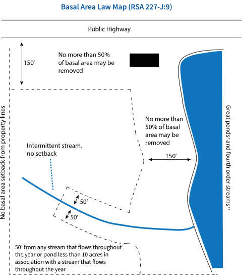
*Great pond means any body of fresh water having an area of 10 acres or more.
**Fourth order streams are those streams on a list maintained by the office of strategic initiatives, as of the effective date of this section, using the Strahler method whereby the highest year-round streams in a watershed are first order streams, their juncture yields second order streams, the juncture of second order streams yields third order streams, and the juncture of third order streams yields fourth order. See NHDES Consolidated List of Water Bodies. Legal definition per RSA 227-G:2, XII
Basal Area Defined
Basal area means the cross-sectional area of a tree measured four-and-a-half feet from the ground. It is expressed in square feet per acre. Simply stated, basal area is a measure of tree density on each acre of land. The higher the basal area, the denser the forest
What Does the Law Say?
The law says that no more than 50 percent of the basal area may be cut or otherwise felled within a 12-month period, leaving a well distributed stand of healthy, growing trees:
Within 150 feet of:
- any great pond*
- any fourth order stream**or higher
- public highway (The basal area law doesn’t apply to Class VI roads)
Within 50 feet of:
- any other stream, river, or brook that is not a fourth order or higher stream which normally flows throughout the year.
- any standing body of water less than 10 acres associated with a stream, river or brook, which normally flows throughout the year.
Obtaining a Variance for Land Remaining Forest
A landowner may request a variance from the Director of the Division of Forests and Lands to cut more than 50 percent of the basal area along roads, water bodies, or streams. The written request must come at least 30 days before cutting begins and include the reason(s) why the variance is necessary along with a map showing the location of the property. If the harvest requires approval from local zoning or planning officials, written evidence of such approval must be included with the variance request.
A Basal Area Variance Request Form can be found on the New Hampshire Division of Forests and Lands website.
Land Being Converted to Other Uses Is Exempt, but Conditions Must Be Satisfied
Timber cutting for land conversion, other than timber growing and forest uses, is exempt from the basal area law if those persons intending to convert the use of the land have secured all required local permits including, but not limited to, building, subdivision or zoning permits, excavation permits, or site plan approval necessary for the use to which the land will be converted and are able to furnish proof of such permits.
Timber cutting for land conversion purposes, other than timber growing and forest uses, that does not require any local permits shall be exempt from this section if conversion occurs within 180 days of exceeding the basal area provisions, unless there is written consent from Director of Forests and Lands to extend the 180-day period.
If the land is being cleared for a proposed subdivision involving the construction of any building from which sewage or other wastes will discharge or construction of a sewage or waste disposal system, the subdivision plan must have been submitted to and approved by the Water Supply and Pollution Control Division of DES in accordance with RSA 485- A:32, III, and RSA 227-J:9, III, before any road construction or land clearing begins.
The Basal Area law shall be enforceable by the municipality in which the land is situated; provided, however, that before initiating any enforcement action, the municipality shall notify the Director of the Division of Forests and Lands, who shall take action to the extent the director deems necessary to ensure uniform statewide enforcement. If, within 10 days of notification to the director, no enforcement action has been taken by the director or the director’s agent, the municipality may proceed with actions necessary to ensure compliance with the law.

*Great pond means any body of fresh water having an area of 10 acres or more.
**Fourth order streams are those streams on a list maintained by the office of strategic initiatives, as of the effective date of this section, using the Strahler method whereby the highest year-round streams in a watershed are first order streams, their juncture yields second order streams, the juncture of second order streams yields third order streams, and the juncture of third order streams yields fourth order. See NHDES Consolidated List of Water Bodies. Legal definition per RSA 227-G:2, XII
Slash Law (RSA 227-J:10)
Slash consists of debris that remains after timber is harvested. These branches, leaves, stems, unmerchantable logs, and stumps may take several years to decompose. Slash, in addition to its messy appearance, represent a wildland fire hazard. The Slash Law is intended to reduce fire danger caused by slash. The slash law improves aesthetics and protects structures, roadways, and waterbodies.
What Does the Law Say?
No logging slash may be left:
- In any river, stream or brook that normally flows throughout the year, or any other standing body of water, public highway, or active railroad bed.
- On the property of another, or in a cemetery
- Within 25 feet of land of another, or fourth order stream
- Within 50 feet of any great pond, any other standing body of water 10 acres or more in area, public highway, or active railroad bed.
- Within 100 feet of any occupied structure (RSA 635:1, III) including all barns, sheds, and other storage buildings, except a temporary lumber camp.
Slash may not be more than four feet high within 50 to 150 feet of any great pond, standing body of water 10 acres or more in area, or public highway.
NOTE: According to RSA 482-A:3, No fill shall be placed in a wetland/surface water unless authorized by DES. DES considers slash as fill. Therefore, slash generated from forestry/harvesting activities is not allowed to remain in wetlands/surface waters
Laws Governing Public Roadways
The focus of this manual is largely on what happens in the woods, and the laws that regulate the activity of loggers, foresters, and landowners in process of accessing and moving timber around in the forest. However, all forest products must at some point enter the public road system, and all equipment must access properties through public roads. To do this safely and legally, loggers, foresters, landowners, and municipalities should understand their rights and responsibilities when moving forest products and equipment to and from private properties. The following document is an important resource for understanding laws governing public roadways:
Forest Products Road Manual – A Handbook for Municipal Officials and the Forest Products Manual.
Maximum Weight Limits on Class IV, V, and VI Roads (RSA 231:190-191)
A town or city may set road limits, on a seasonal or permanent basis, that are more restrictive than state law. Cities and towns that have enforceable weight limits must comply with the following:
- Whenever the governing body (selectman or council) votes to establish a weight limit (whether year-round or seasonal) the written minutes of the meeting where the vote occurs should reflect testimony from the road agent or highway engineer that the limit was necessary “to prevent unreasonable damage or extraordinary municipal maintenance expense,” citing facts and experience as much as possible to back up this conclusion.
- The limit must be posted at all entrances from other highways using weather resistant materials.
In addition to the above municipalities should consider:
- Violators of properly enacted weight limits are guilty of a violation and in addition are liable for restoring the road.
- Selectman, road agents, or street commissioners are given authority to grant exemptions in writing. Bonding and restoration can be required as a condition of granting an exemption, but the municipality can’t impose restoration costs on anybody without “reason to believe that the …damage...is attributable” to that person. A bond, properly speaking, is simply an agreement between a landowner and a municipality stating that the landowner agrees to do a certain thing and accompanied by some type of security for the municipality to draw upon if the landowner fails.
- If the weight limit causes significant interference with any land use or enterprise that existed prior to the posting, this will constitute hardship entitling the landowner to an exemption, if bonding and restoration requirements are compiled with and the exemption would not be detrimental to public safety.
Rights-of-Way for Removal of Lumber (RSA 231:40-42)
Occasionally, it becomes necessary to obtain a right-of-way through the land of another to access lumber, wood, or other material. If a right-of-way location has not been agreed on by the owners, the selectman may designate a right-of-way. The use of RSA 231:40-42 to obtain access to remove lumber, wood or other material should be carefully considered and seen as a last resort. The owners should be encouraged to work with each other along with local private consulting foresters and other professionals to a mutual agreement.
After notifying the owner of the lands on which the right-of-way will pass, the selectmen shall determine the necessity for, and damages caused by the right-of-way before it is open for use.
Any person aggrieved by the action has the right to appeal. Selectmen:
- may set the time and conditions under which the right of way may be used.
- may order the right-of-way closed or discontinued when, in their judgment, it is necessary.
- shall set a time for examining the premises and hearing parties in interest and give 12 days notice to one or more of the petitioners and to the persons owning or having an interest in lands through which the right-of-way will be laid out, altered, or discontinued.
- shall also give notice when a right-of-way is altered or discontinued.
- shall indicate when they will consider claims for damage.
- shall publish a notice in a local newspaper not less than 10 days before the time set for the hearing.
Licensed Foresters (RSA 227-J:4)
New Hampshire licensed professional foresters provide a variety of services to landowners including management plan preparation, timber appraisals, timber sale administration, wildlife habitat improvement, boundary marking, timber stand improvement, and recreation and aesthetic improvements. In addition, some foresters may have particular qualifications and interest in providing assistance in land surveying, urban forestry and landscape, Christmas trees, taxation, legal or other natural resource-related matters.
RSA 227-J:4 states “it shall be unlawful for any person to practice for compensation or offer to practice for compensation in this state, the profession of forestry, as defined in RSA 310-A:99, II, or to use in connection with a name or otherwise assume, use, or advertise any title or description tending to convey the impression that such person is a forester, unless such person has been duly licensed according to the provisions of RSA 310-A. Failure to comply with these requirements may result in penalties under RSA 310-A.”
Land Conversion/Development Harvesting Laws
New Hampshire law makes a distinction between timber harvesting for forest management and timber harvesting that takes place to convert land to non-forest uses such as in development. The following chart summarizes restrictions that apply to land conversion, and those that apply to forestry, with statutory references in parenthesis.
| State Law | Land Conversion | Forestry |
| Notice of Intent to Cut Wood or Timber (RSA 79) | Required when cutting greater than 15 MBF and 30 cords and 300 tons of whole tree chips | Required, some exceptions apply |
| Wetlands: Forestry Statutory Permit-by-Notification (SPN)(RSA 482-A:3, V) | Can’t be used | Required if wetland impact is minimum |
| Wetlands: Permit-by-Notification (PBN)(RSA 482-A:11) | Can’t be used | Can be used for minimum impacts outside the criteria permitted with the SPN |
| Wetlands: Standard Dredge & Fill (RSA 482-A) | Required if land conversion impacts wetlands | Can be used for minor or major impacts outside the criteria permitted with the SPN and PBN |
| Alteration of Terrain (RSA 485-A:17) |
Required if > 100,000 sq. ft. (2.3 acres) is disturbed (Excavating, stumping, etc.), 50,000 sq. ft. within shoreland protection zone, or > 0 sq. ft. on a 25% or greater slope within 50 ft. of a surface water (RSA 483-B:9,V) | Required, but Notice of Intent to Cut Timber Certificate serves as permit (RSA 485-A:17, III); Disturbance must not exceed limitations in previous column. |
| Basal Area Law (RSA 227-J:9) | Applies unless all required local permits have been secured and land is converted within 180 days | Applies unless variance has been obtained from Division of Forests & Lands (Class VI Roads exempt) |
| Slash Law (RSA 227-J:10) | Applies | Applies |
| Shoreland Water Quality Protection Act (RSA 483- B:9, V) |
Shoreland Permit is required for any dredge, fill, or construction project within 250 linear feet of fourth order and higher streams, designated rivers, and water bodies >10 acres | Not applicable |
| Natural Heritage Bureau (RSA 212-A; 212-B; 217-A) |
Required with all wetland/shoreland applications |
Required for Forestry Statutory Permit-by-Notification (SPN). Otherwise not applicable |
Invasive Species (RSA 430:51-57) (Agr 3800)
The adverse environmental and economic effects of invasive plants, insects, and fungal species upon the state is well recognized. We are all legally responsible to prevent and control the spread of invasive species in the state to achieve the best possible protection of agricultural, forest, wildlife, other natural resources, and human health.
What the Law Says About Invasive Species:
No person shall collect, transport, import, export, move, buy, sell, distribute, propagate, or transplant any living and viable portion of any plant species, which includes all of their cultivars and varieties, listed in Table 3800.1, New Hampshire prohibited invasive species list. (Agr 3802.01 (b))
No person shall collect, transport, import, export, move, buy, sell, distribute, propagate, or release any living insect species listed in Table 3800.1, New Hampshire prohibited invasive species list. (Agr 3802.01 (c))
It shall be a violation for any person who collects, transports, imports, exports, moves, buys, sells, distributes, propagates, or transplants any living and viable portion of any plant species, which includes all of their cultivars and varieties, listed in Table 3800.1, New Hampshire prohibited invasive species list. (Agr 3802.06 (a))
Resources for Understanding and Minimizing the Impacts of Invasive Species:
- Invasive Species Best Management Practices: Guidance for the U.S. Forest Service Eastern Region
- New Hampshire Department of Agriculture Markets and Food (NHDAMF): Invasive Plants
- New Hampshire Guide to Upland Invasive Plants
- New Hampshire List of Prohibited Invasive Plants (Table 3800.1)
- New Hampshire List of Prohibited Invasive Species (Includes Insects) (Table 3800.1)
- NHBugs
- UNH Cooperative Extension: Invasive Species Information
Town officials can play a vital role in the enforcement of timber laws. While this publication provides general information on laws that apply to timber harvesting, municipal officials should also have complete copies of all relevant statutes and administrative rules.
Become Familiar With the Laws
Selectman may delegate responsibilities for reviewing timber harvesting operations to a code enforcement officer, the conservation commission, a designated forestry committee, a law enforcement officer, or a licensed forester working for the town. Some towns employ a “timber tax monitor” usually on a part-time basis to keep track of timber harvesting activity, report filing, and payment of timber tax.
Conservation commissions may ask the town assessing officials to notify them when an Intent to Cut Timber form has been filed. Some towns now routinely provide information and materials such as New Hampshire Best Management Practices for Erosion Control on Timber Harvesting Operations to those filing an Intent to Cut Timber form. Town road agents can also inform the conservation commission of the location of logging or land conversion activities.
After determining the location of the logging operation and whether it is forestry work or land conversion for development (different laws apply), the conservation commission, after obtaining landowner permission, can check the operation for compliance. Remember, a conservation commission or a board of selectman does not have legal authority to enter private land without first obtaining permission. An effort should be made to work constructively with the landowner and logger. It is wise to be sure that a potential violation exists before filing a complaint or reporting the problem to proper authorities.
Please note that a Forestry SPN cannot be used if the property is slated to be converted for development, subdivided into multiple lots, or any other non-forestry use.
What to Look For at the Site
Unless exempted, a logging operation should comply with the following:
- A timber cutting operation may not start until one of the following is posted in a conspicuous place within the area of cutting:
- The certificate from DRA
- A copy of the notice of Intent to Cut signed by the assessing officials; or
- A copy of the notice of Intent to Cut with the operation number along with the date, time and name of municipal official or employee who provided the operation number.
- Either a Confirmation of a Complete Forestry Statutory Permit-By-Notification (SPN), or possibly a Wetlands Permit-by-Notification (PBN) from the New Hampshire Wetlands Bureau must be posted on the site. They are not required if no wetlands or surface water bodies are impacted. If no form or permit is present, and you believe one is required, you should contact the Wetlands Bureau.
- In general, there should be a well-distributed stand of healthy trees along roads, except for Class VI roads, which are exempt from the basal area law (RSA 227-J:9). If the trees have been completely removed from along the road, the Division of Forest and Lands should be contacted to determine whether the landowner has applied for a variance to the basal area law. If the land is being converted to non-forest uses, the basal area law may not apply, but local and state officials should be contacted to see that the appropriate permits have been obtained.
- In general, there should be no large piles of slash near roads or lakes. Slash and slash piles may be present when cutting takes place in these areas but should be removed promptly. When this condition is not met, contact the Division of Forests and Lands.
- If the owner is disturbing (damaging) a public highway (including Class VI), permission must be sought under RSA 236:9.
Get Help
The NH Division of Forests and Lands forest rangers are available to help town officials enforce timber harvesting laws. Forest rangers have the authority to enforce laws relating to Basal Area and Slash (RSA 227-J), Wetlands (RSA 482-A), Alteration of Terrain (RSA 485-A:17), Timber Tax (RSA 79). When potential violations are encountered, the forest ranger for that region should be notified immediately by calling the Forest Protection Bureau in Concord at (603) 271-2214. Timber tax issues or questions should be directed to the Dept. of Revenue Administration at (603) 230-5950.
Who Has Authority to Enforce or Assist in Enforcing Regulations?
The following table lists important regulations and the official bodies responsible for their enforcement.
| Regulation | Enforcement/Authority |
|---|---|
| Timber Tax Enforcement | NH Dept. of Revenue Administration NH Division of Forests & Lands Town Tax Assessor or Town Selectmen |
| Dredge-and-Fill Permits | NHDES Wetlands Bureau Town Planning Board Town Selectmen Town Conservation Commission NH Division of Forests & Lands |
| Wetland Forestry Notification | NHDES Wetlands Bureau NH Division of Forests & Lands |
| Basal Area Law | NH Division of Forests & Lands Municipality, after notifying NH Division of Forests and Lands |
| Slash Law | NH Division of Forests & Lands |
| Timber Trespass | NH Division of Forests & Lands |
| Deceptive Forestry Practices | NH Division of Forests & Lands |
|
New Hampshire Department of Natural and Cultural Resources, |
UNH Cooperative Extension, Forestry & Wildlife 225 Nesmith Hall, 131 Main Street, Durham, NH 03824 (603) 862-1028 nhwoods.org |
|
New Hampshire Department of Revenue Administration |
New Hampshire Department of Environmental Services, Wetlands Bureau P.O. Box 95, Concord, NH 03302-0095 (603) 271-2147 or, for other DES matters (603) 271-3503 des.nh.gov/water/wetlands |
| New Hampshire Timberland Owners Association 54 Portsmouth Street Concord, NH 03301 (603) 224-9699 nhtoa.org |
New Hampshire Timber Harvesting Council 54 Portsmouth Street, Concord, NH 03301 (603) 224-9699 |
| New Hampshire Department of Agriculture, Markets, and Food Division of Plant Industry PO Box 2042 Concord, NH 03302 -2042 (603) 271-3551 www.agriculture.nh.gov/divisions/plantindustry/ invasive-plants.htm |
UNH Cooperative Extension Educators, Forest Resources
|
Belknap County |
Hillsborough County Michael Gagnon 603-641-6060 michael.gagnon@unh.edu |
| Carroll County Wendy Scribner 603-447-3834 wendy.scribner@unh.edu |
Merrimack County Tim Fleury 603-796-2151 tim.fleury@unh.edu |
| Cheshire County Matt Kelly 603-352-4550 matt.kelly@unh.edu |
Rockingham County Greg Jordan 603-679-5616 greg.jordan@unh.edu |
| Coös County Ray Berthiaume 603-788-4961 ray.berthiaume@unh.edu |
Strafford County Lindsay Watkins 603-749-2529 lindsay.watkins@unh.edu |
| Grafton County Jim Frohn 603-787-6944 jim.frohn@unh.edu |
Sullivan County Dode Gladders 603-863-9200 dode.gladders@unh.edu |
UNH Cooperative Extension Specialists, Forestry and Wildlife
| Steven Roberge Forest Resources 603-862-4861 steven.roberge@unh.edu |
Haley Andreozzi Wildlife Conservation 603-609-0927 haley.andreozzi@unh.edu |
| Andrew Fast Forest Industry 603-862-2402 andrew.fast@unh.edu |
Matt Tarr Wildlife Habitat 603-862-3594 matt.tarr@unh.edu |
Resources Referenced Throughout the Document
- Basal Area Variance Request Form
- Current Stumpage Ranges: DRA Website: Municipal and Property > Property Bureau > Timber Bureau
- Forest Products Road Manual – A Handbook for Municipal Officials and the Forest Products Manual
- Forest Stewardship and Current Use: A Primer
- Forestry Statutory Permit-By-Notification (SPN)
- Good Forestry in the Granite State
- New Hampshire Best Management Practices for Erosion Control on Timber Harvesting Operations
- New Hampshire Department of Environmental Services (NHDES)
- New Hampshire Department of Revenue Administration (DRA)
- New Hampshire Department of Revenue Administration: Current Use Information
- New Hampshire Directory of Licensed Foresters
- New Hampshire Division of Forests and Lands
- New Hampshire Fish & Game: Nongame & Endangered Wildlife Program
- New Hampshire Natural Heritage Bureau (NHB)
- New Hampshire Natural Heritage Bureau (NHB) DataCheck Tool
- Notice of Intent to Cut Wood or Timber (PA-7) Form
- UNH Cooperative Extension Forest Resource Educators
- Vernal Pools and the Surrounding Forest
Resources related to the Shoreland Water Quality Protection Act
- Protected Shoreland FAQ
- Shoreland Water Quality Protection Act (SWQPA): A Summary of the Minimum Standards
- Vegetation Management for Water Quality
Resources for Understanding and Minimizing the Impacts of Invasive Species
- Invasive Species Best Management Practices: Guidance for the U.S. Forest Service Eastern Region
- New Hampshire Department of Agriculture Markets and Food (NHDAMF): Invasive Plants
- New Hampshire Guide to Upland Invasive Plants
- New Hampshire List of Prohibited Invasive Plants (Table 3800.1)
- New Hampshire List of Prohibited Invasive Species (Includes Insects) (Table 3800.1)
- NHBugs
- UNH Cooperative Extension: Invasive Species Information
This publication was originally prepared by:
- Sarah Smith, UNH Cooperative Extension Forest Industry Specialist & Professor
- Debra Anderson, UNH Cooperative Extension Administrative Assistant
This publication was revised in 2024 by:
- Michael Gagnon, UNH Cooperative Extension Field Specialist, Hillsborough County
- Steven Roberge, UNH Cooperative Extension Forestry Professor & Specialist
We wish to thank the following for their review of this publication:
- Rick Evans, NH Department of Revenue Administration
- Andrew Fast, UNH Cooperative Extension
- Amy Gaudreau, UNH Cooperative Extension
- Steven Sherman, NH Division of Forests and Lands
University of New Hampshire Cooperative Extension
59 College Road, Taylor Hall, Durham, New Hampshire 03824 | www.extension.unh.edu
NH Division of Forests and Lands
172 Pembroke Rd., Concord, NH 03302-1856 | www.nhdfl.dncr.nh.gov
New Hampshire Timberland Owners Association
54 Portsmouth Street, Concord, New Hampshire 03301 | www.nhtoa.org

Contact

