Sensors by the Seashore
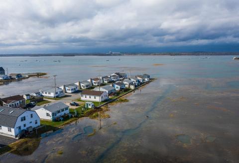
Owning a piece of the New Hampshire coastline is a dream for some — a home surrounded by nature, close to beautiful beaches with views of sunsets over the marshes. But living on the coast increasingly comes with the threat of flooding as sea levels rise.
“When I first bought this property, flooding was maybe a couple of times a summer, and then it started getting chronic every month,” says Steve Belgiorno, who owns several properties around Manchester Street in Hampton.” Now, if we miss a month, we have a party.”
Coastal flooding in New Hampshire is expected to increase in severity and frequency in the future. For residents in Hampton, sea level rise means water damage to their homes, their cars and their property.
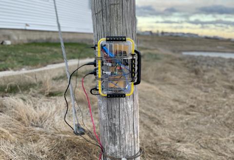
That’s why New Hampshire Sea Grant and UNH Extension are working with UNH’s Innovation Scholars Program. Undergraduate engineering students in the program are designing and building a lending library of sensors that can help New Hampshire’s coastal residents understand their flood risk and flood damage.
Last fall, Innovation Scholars met with local residents and business owners in Hampton to see and hear firsthand the impacts of coastal flooding. Over the subsequent months, the students engineered two types of sensors to address the issues they heard about and saw: a wave buoy to measure the effects of incoming storms that can push high water into low-lying communities and a water quality sensor to detect the presence and acidity of water that may be degrading the concrete foundations of some homes.
"We need to give people the power to make decisions in their own lives,” says Jane Schwadron ’24, a member of the Innovation Scholars’ wave buoy team, noting those decisions can be as small as moving their cars or as significant as elevating their houses. “We need to give people the power of information.”
The lending library of sensors will be open to the community as well as nonprofit organizations, such as the Seabrook Hampton Estuary Alliance (SHEA), to help bolster community efforts to prevent and mitigate flooding in the future. “We’ll have on-the- ground metrics that people can use, which
I think is going to be a phenomenal piece of information for understanding even more about exactly where flooding is occurring and what the extent of that flooding is going to be,” says Jay Diener, president of SHEA.
In spring 2021, the students ran the first tests of their sensors, providing valuable insights on their utility and designs. Once the sensors are finalized, the students will make multiple copies to be stored in the sensor lending library for residents, citizen scientists and future students wishing to collect local data in Hampton and elsewhere in coastal New Hampshire.
“Anytime we can get data from our community, it only helps us to better understand what the impacts are,” says Rayann Dionne, a former conservation coordinator for the town of Hampton.
“I think for property owners and residents and people in the community, sometimes that's just hard to wrap your head around. Like what does sea level rise really look like?”
Bringing together community members, resource managers, students, faculty mentors and Extension professionals for this project proved to be an effective and exciting opportunity for engaged scholarship that met residents where they were — in their own homes and neighborhoods — to deliver science- and technology-based approaches to the shore.