Seacoast Landowners Learn How to Prepare for and Mitigate Flood Risks

For residents of the New Hampshire Seacoast, life often brings sunny days on the beach, fishing and kayaking along the inlets and eating delicious local seafood. But as the climate warms and sea levels rise, ocean water has become an encroaching threat for coastal landowners. Low-lying coastal communities are increasingly vulnerable to natural hazards and looking to adapt to a changing environment.
According to UNH Extension and NH Sea Grant coastal ecosystems specialist Alyson Eberhardt, “People are seeing two things: They're seeing sunny day flooding, which is flooding associated with large tides, not with storms, and then they're certainly seeing more impacts associated with storms.”
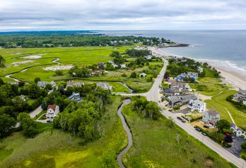
In 2017, longtime New Hampshire residents Michael and Denise Tager moved to a small neighborhood called Fifield Island behind North Hampton Beach. Fifield Island is encircled by a salt marsh with just a single access road. Although Fifield Island is not in a flood zone, the Tagers are surrounded by one.
Sunny day flooding and storm surge are enough to make any landowner nervous, and UNH researchers and staff at the NH Department of Environmental Service’s (NHDES) Coastal Program started hearing from residents, like the Tagers, looking to make changes.
“We've been increasingly seeing landowners reach out to us to ask us about how to deal with erosion and other flooding issues,” says Kirsten Howard, coastal resilience coordinator at NHDES.
In response, Eberhardt, Howard and UNH faculty colleagues David Burdick and Gregg Moore spearheaded a UNH and NHDES cooperation — the Coastal Landowner Technical Assistance Program (LTAP) — to guide residents through assessing and mitigating flooding and erosion risk on their properties. Since launching in 2019, LTAP has helped close to 20 New Hampshire property owners.
Michael Tager first contacted NHDES with flooding concerns and soon became an LTAP participant. “The LTAP team helped me to think beyond just this one topic of needing flood insurance and to look more carefully at the neighborhood and New Hampshire coastal flood risks,” Tager says.
The program begins with a property survey to gauge the landowners’ goals and priorities, informing an initial site visit. “We do an assessment of their property, but we also provide them with some very basic information that's fairly easy to put together about where they are in the regulatory floodplain, what sea-level rise might look like on their property in the future,” says Howard. The second phase brings landowners more specific recommendations in a report that LTAP specialists tailor to each property and owner’s needs.

“I now have a ‘punch list’ of suggestions to think about and implement, from simply installing a sump pump to continuing to pursue flood insurance to revisiting our landscaping to improve on drainage from the house,” Tager says. These recommendations can be very different for each landowner.
“Property owners have very different goals, very different willingness to accept risk,” Howard says. “There's no silver bullet answer for any property owner. Some of the process is helping them to come to an understanding or make peace with the fact that a lot of the actions and decisions they're going to have to make, or not make, are up to them.”
The program showed Tager that his property’s risk is greater than he once thought. “This is a more critical and time-sensitive issue than I had imagined. It will impact not just our home and our neighborhood but the entire coastline, with environmental, economic and social consequences,” he says.
Eberhardt and Howard hope to continue to help landowners and communities make informed decisions about their coastal properties, and LTAP participants like the Tagers may be the best ambassadors.
“I would like to introduce my neighbors to LTAP, especially those who abut the salt marsh,” Tager says. “I think it would be very productive to invite my neighbors to hear more about LTAP from a terrific team of knowledgeable, experienced and passionate staff. And I know just who to invite to make that presentation!”