Well-Being of Beaches
It’s the first beach day of the year on the Seacoast. You’ve got towels, chairs, sunglasses and sunscreen, and you’ve just taken your first step onto the warm sand. Does the beach look the same as it did during your last visit? Have you ever stopped to notice the contour of the coastline?
For New Hampshire communities that rely on tourism and revenue from beachgoers, shifting sands can have significant impacts.
Every year, beaches are reshaped by the waves that crash into the sand and scrape it back out to sea. If a strong Nor’easter or hurricane blows through, a beach can transform overnight. Beyond single weather events, beaches naturally experience erosion (losing sand) and accretion (adding sand) over months, years and decades, which changes the character of our sandy shorelines.
These natural cycles have also been altered by human activities like coastal development, climate change and shoreline armoring — the practice of using physical structures to protect shorelines from coastal erosion.
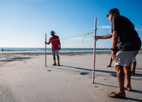
To track these changes, Coastal Research Volunteers (CRV) have been measuring beach profiles at 13 sites on six beaches in New Hampshire every month for the past six years. CRV is a citizen science program managed jointly by UNH Extension and N.H. Sea Grant. Volunteers gather data about trends in beach erosion and accretion, which can be used by beach managers, municipalities and agencies like N.H. State Parks.
For Chris Williams, program manager at the N.H. Department of Environmental Services’ (NHDES) Coastal Program, the value of this volunteer-collected data is easy to see. According to Williams, dredging projects – like the one recently completed in Hampton Harbor – often result in excess sand and sediment. One potential use for the dredged material is beach nourishment, meaning that sand is added to eroding beaches to replenish lost sand and increase beach resiliency.
Beaches closest to dredging operations most frequently receive nourishment, usually because transporting sand is expensive. But based on the CRV data, Williams says that Hampton and Seabrook may not need extra sand, whereas other beaches along the coast, like Wallis Sands, could use the boost. CRV’s beach profiling data, which measures the elevation of the sand as it arcs across the beach to meet the water line, is also helpful for justifying the costs of moving sand to beaches that are located far from dredge sites.
“If we've got a complex or a complete dataset that shows what's happening with this beach, then we can make that argument,” Williams explains.
This kind of high-quality, long-term data would simply not be available (and would be exorbitantly expensive to collect) without the efforts of dozens of community volunteers, coordinated by Coastal Ecosystems Extension Specialist Alyson Eberhardt and CRV Citizen Science Outreach Coordinator Wells Costello in partnership with research associate Larry Ward and research assistant Rachel Morrison from the UNH Center for Coastal and Ocean Mapping.
“Our dataset of over 700 beach elevation profiles would not exist without our team of dedicated volunteers,” Eberhardt explains. “Since the start of the program, we’ve had 60 well-trained community members collect data on New Hampshire’s beaches. This means that in addition to a robust dataset to drive beach management decisions, we also have dozens of engaged community members who are incredibly knowledgeable about our beaches and the challenges and opportunities we will face in the future.”
The CRV beach profiling data is now publicly available in a new online portal created collaboratively by Sea Grant, the UNH Center for Coastal and Ocean Mapping, NHDES Coastal Program and the N.H. Geological Survey. The portal allows viewers to browse a map, pick a beach and then compare profiles taken by the volunteers over the years. The crisscrossing lines illustrate erosion from strong storms, the steady rebuild of a beach and seasonal changes from summer to winter.
“If you overlay these profiles on top of each other, you can definitely start to see some change over time,” Williams says. “That's the kind of information we have to get in front of town municipalities and state associations.”
New Hampshire towns can leverage this data to make the case for beach nourishment from projects like Hampton Harbor, which is dredged about every seven years. When the time comes for the next dredging, towns can be ready to make informed decisions about their coastal resources and plan to protect their beaches for generations to come.

